 Coiled barbwire on Carrizo Plain
I drove out to the Carrizo Plain National Monument after a few days of intermittent rain showers. It is a semi-arid grassland of several hundred thousand acres that remains today, for the most part, as it was hundreds if not thousands of years ago. That alone, in the nation’s most populace state of California, is perhaps a remarkable enough trait in itself to warrant a visit by backcountry gadabouts, those who appreciate the simple pleasure of roaming freely within vast, open natural spaces and unspoiled landscapes. The nearby San Joaquin Valley, by contrast, has been carved up into a patchwork of farm fields, ranches and subdivisions.
I go to the Carrizo Plain when I feel like escaping the artificial metropolitan bubble of humanity and its hurried masses, but don’t feel much like hiking. I enjoy the plain’s winter ambiance, after seasonal rains dampen the dessicated terrain and when the temperatures are cool and lumpy gray clouds float overhead. It is a place I cherish for its serenity and desolation and its palpable silence. At first glance, upon my initial visit years ago, it seemed like a wasteland of little interest, but over the last decade I have developed a rather keen appreciation of its many subtle and dramatic characteristics and the natural and anthropological wonders found there.
 Sun-bleached bone on the plain.
The San Andreas Fault runs through the eastern side of the plain forming the appropriately named Temblor Range. It is here that on January 9, 1857 the 7.9 magnitude Fort Tejon earthquake resulted in a 30 foot offset in Wallace Creek, which can be seen today in the arroyo’s dramatic z-shaped meandering course.
While the northern side of the Temblor Range is sparsely dotted with juniper, the southern face is barren due to the lack of rain. The result is a starkly beautiful landscape with sections of badland terrain. Perhaps the most prominent example of this barren landscape is found in Dragon’s Back Ridge, which has formed as a result of the tremendous pressure created along the San Andreas Fault, where the Pacific Plate and North American Plate slide passed each other.
On this most recent trip I took a walk across the width of the plain and on up to the top of the Dragon’s Back. I had hoped to see some pronghorn antelope or perhaps a San Joaquin Kit fox, but, alas, no such luck. I saw nothing larger than a single jackrabbit speedily bounding away from me. I passed by several empty vernal pools in this relatively dry year, but not much else.
I passed over a couple of undulations in the otherwise flat plain, and as I proceeded farther into the depths of the plain, I turned regularly to look back and note my location relative the distant Caliente Range, which defines the southern flank of the Carrizo Plain, and for some time my truck was hidden from sight.
Later, while on top of the Dragon’s Back, my truck was barely visible and only when the light hit the metal and glass just right to cast a reflection. My vehicle looked puny, a mere speck, against the vastness of the grassy plain. It was not easily seen, which despite carefully surveying the landscape on my way to the ridge to avoid becoming lost, made it easy to lose my place of return.
Of course, use of a GPS would have rendered such concerns irrelevant, but I prefer not to rely too heavily on such technological crutches. They are convenient and handy, but no substitute for real skills. And I also find it more entertaining and satisfying finding my own way rather than having my eyes glued to a machine.
 Approaching Dragon’s Back Ridge.
Dragon’s Back is comprised of a long line of steep gullies and pointy ridges along it’s southern slope. These ridge lines are steep sided and the tops typically span roughly some three to six feet across and form a sort of ramp that can be walked up and down. Animal trails run along each of these pointy ridges or spines and in certain locations here and there atop the main ridge lie piles of animal poop like that of coyotes or foxes. It is clearly an active location though I saw no life. The top of Dragon’s offers commanding views of the Carrizo Plain.
In late afternoon dark clouds condensed over the ridge casting a deep shadow over the plain. My truck no longer reflected sunlight and it disappeared from sight. As I headed down the ridge back to the plain I took a bearing on a prominent feature of the distant Caliente Range, which corresponded to the location of my truck, and headed toward it hoping not to stray too far from where I needed to go.
As I made the final approach to where I had parked, a hole formed in the dark cloud blanket overhead and a bright shaft of sunlight shown from above on my truck like a giant spotlight. I turned for a last look a Dragon’s Back and the golden light of late afternoon illuminated the ridge against a blackened backdrop of thick cloud cover.
 Walking up one of the spines on the ridge.
 Looking west from the top of Dragon’s Back.
 Looking east at the ridge I walked down to get back to the plain.

 A raptors nest in what might be the only tree on the Carrizo Plain, Dragon’s Back Ridge in the background.
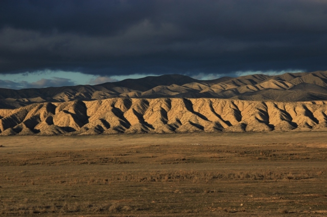 Dragon’s Back in the golden glow of late afternoon sunlight.
 A Red–tailed hawk I flushed off the ground when checking nearby Soda Lake prior to visiting Dragon’s Back.
Related Posts:
The Carrizo Experience: Ten Hours on the Plain I: Ruminants on the Range.
The Carrizo Experience: Ten Hours on the Plain II: The Bedrock Mortars of Selby Rocks.
The Carrizo Experience: Ten Hours on the Plain III: Pictographs of the Plain
The Carrizo Experience: Ten Hours on the Plain IV: Soda Lake
Wallace Creek Offset at the San Andreas Fault
Cave’s Eye View on the Carrizo Plain
Summertime Soda Lake
Soda Lake Winter Reflections
Elkhorn Plain
Selby Rocks
Carrizo Plain Wildflowers
Datura Bloom on the Carrizo
Carrizo Tom








With this post, you have made the day of a lonely California ex-pat burrowed in the Midwest. The beauty and solitude of the Carrizo Plain is palpable from your photographs and the chronicle of your hike. Loving those desolate places. Thank you.
Hey Terry. Glad to hear you enjoy the content! Thanks for stopping by.
The last 3 pictures of the Dragon’s Back Ridge are my favourites and are really superb. What a great place that looks to hike. I have to admit that I had no idea you had so much good hiking over there.
I had to laugh at where you said there was a lot of cloud over the ridge though – it’s rare we ever have clear skies and most times it’s completely overcast here. We could use some of that sunshine 🙂
Carol.
I sometimes get tired of all the sunny blue skies around here, believe it or not. Though it happens to be overcast at the moment.
Yeah, I can nearly imagine that – I know Australians and the like, when they visit us here, love it when it rains or snows!
Dragons Back is a wonderful place to visit, and thanks to you I was able to experience it. I love the captures you have from your adventure. Thanks Jack!
Great photos and great story…I love the Carrizo Plain. I drag my wife there every once in a while, and we scramble around the rocks and brush randomly. I always see something new to me there – on my last trip it was antelope squirrel and a golden eagle. I think it’s time to head back, you’ve inspired me.
Excellent… Thank you for sharing this. Last spring I slept at the Shelby camp and walked the Caliente ridge. The payoff is the highest peak in SLO county, and glorious views of the carizzo plain and neighboring Cuyama valley. It was awesome. I saw 3 people all day.
Nice shots of the Dragons Back. I read a road cuts through there? What is best to see this up close? Thanks
Nice pictures. Is there a road that cuts through the Dragons Back? New to that area. Thanks
There’s a road that brings nearby but nothing cutting through that I am aware of.