
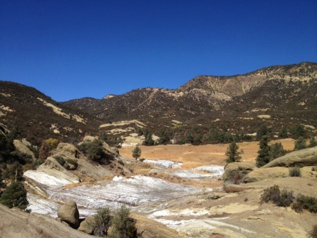
 The place. Note the white mineral deposit on its far side.
“Our history is carried by word of mouth, but it’s anchored to the land. The old boys used to play a game: one of them would leave his cap on a rock, somewhere in the mountains. Then he’d go into the pub and tell the name of the rock to a friend. That was all the information they needed. The friend had to run out and retrieve it. All the rocks had names. My uncle could remember all of them. They were never written down.”
—Dafydd Morris-Jones, as quoted by George Monbiot in “Feral: Rewilding the Land, the Sea, and Human Life” (2014)
So far as I know, which isn’t much, this here field is officially unnamed. How has it escaped this long? Isn’t everything labeled these days? It seems like a remarkable enough place that it would have a name by now.
Among the Chumash, the Spaniards and Californios and early Americans that followed, surely the place had a name. Through the years, the millennia, at some time it must of had a name.

“It’s landscape associative. Folk traditions and oral history always have been. Professional history tends to regard a fascination with place as antiquarian. But mythology is all about place. . . . I wish the West Texas pioneers, like those in the Far West, the Deep South, even New England, had learned and retained more of the Native American names once attached to these canyons.”
—Dan Flores, “Caprock Canyonlands: Journeys into the Heart of the Southern Plains,” (1990)
As with the Comanche and Kiowa of which Flores writes, sense of place and the importance of the landscape figured prominently in Chumash culture. Whereas in American culture places are often named after people, the Chumash tended to name people after places. Each prominent geographical feature likely had a name and placenames were commonly taken from minerals found in the area. Applegate quotes Harrington: “In ancient times there must have been placenames all up and down the canyons.”
A place of this remarkable nature — a grassy flat with a mineral deposit, near a river once stuffed with steelhead trout, at the foot of pine capped mountains once teeming with game — seems like it would have been an attractive location in times past. It’s just a wild guess.
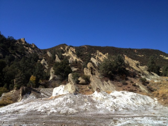
When I hiked through in 2011 I don’t recall the area being as salty as it was this last summer. Maybe because back during that particular season a lot of rain had fallen, 160 percent of normal county-wide up in Santa Barbara, and the minerals were diluted by abundant freshwater.
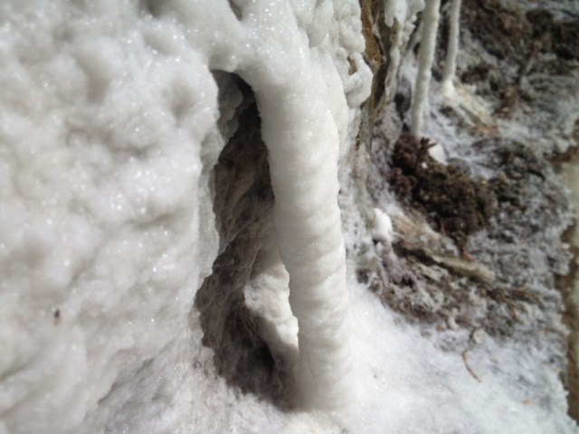
After several years of drought the crusty white buildup was much more extensive in late 2015, as shown in the snapshots. In some places the crystals were finely shaped and well-developed. Small puddles of extremely concentrated salt water pooled in the cavities of the rock that when stirred with a stick swirled like oil in water.
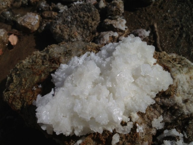
The word for salt in Barbareno Chumash is tip. Adding emphasis through reduplication signifies that there is a lot not just a little. Thus tiptip may be roughly translated as “lots of salt.”
“Goleta Slough was called tiptip, ‘salina, salt flat,’ and not surprisingly, the Ventureno equivalent sitiptip was applied to Hueneme lagoon,” Applegate writes.
Alternatively, sitiptip might be understood to mean “the place with lots of salt.”
 A dribble of resin oozing from the leaf bud of a black cottonwood tree (Populus trichocarpa) growing along the Santa Ynez River.
 A bud post-pop, the leaves sticky and redolent of the fragrant resin.
 Ooey gooey fragrant bud resin.
 Goatfell Peak by silhouette from Brodick Bay.
 A view of Brodick Bay from the stony trail up to Goatfell Peak.
 Goatfell summit looking across at Cir Mhor or the “Great Comb.” (Properly pronounced
 Blasted by a piercing wind, jacket and pants inflated and puffy, we admire a wee wrinkle of hills.
 Micah and Chloe, center-frame, walking downhill on the hillwalk down from Goatfell Peak. Micah is the frontman for the popular band,
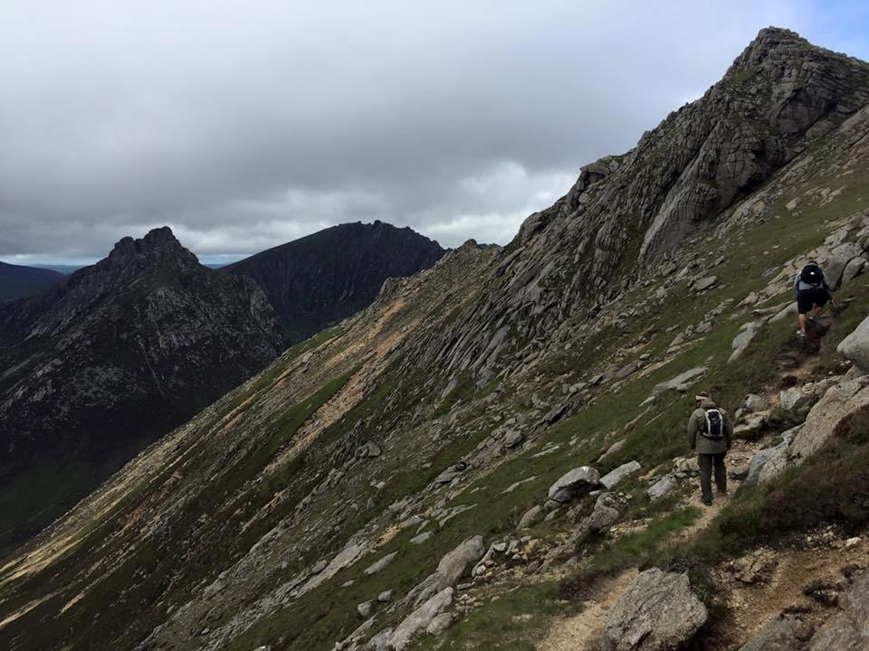
 Looking over the course of the trail from just below Goatfell Summit. The trail weaves through the boulders and on along the ridgeline, up the lesser peaks and down into the saddles between. Then down to a final saddle at the foot of Cir Mhor before dropping into the top of Glen Rosa.
 A view of Glen Rosa below.

 Having descended from Goatfell to the bottomlands of Glen Rosa with trout in the stream.


 A hankering had taken hold of my mind since the first fall of recent rains and I desperately needed to get out into the wet hills. I turned off the pass and onto a byway only to then abort the idea, and turn around and continue on down the highway to somewhere else, yet still not sure exactly where I was headed.
 Looking up at Ranger Peak.
 Light showers began drizzling from the clouds shortly before I reached the top of the peak. The sight and sound of falling rain, the rich fragrances wafting from a wetted earth, wild herbs, grasses and scrub and the moody ambiance of a cloudy winter day on Figueroa Mountain. After four years of record drought, a hike through water falling from the sky was a gloriously sensual and invigorating experience.
 Trail through the trees.
 The view from Ranger Peak looking into the San Rafael Wilderness backcountry.
 A rainbow over


