
 The place. Note the white mineral deposit on its far side.
“Our history is carried by word of mouth, but it’s anchored to the land. The old boys used to play a game: one of them would leave his cap on a rock, somewhere in the mountains. Then he’d go into the pub and tell the name of the rock to a friend. That was all the information they needed. The friend had to run out and retrieve it. All the rocks had names. My uncle could remember all of them. They were never written down.”
—Dafydd Morris-Jones, as quoted by George Monbiot in “Feral: Rewilding the Land, the Sea, and Human Life” (2014)
So far as I know, which isn’t much, this here field is officially unnamed. How has it escaped this long? Isn’t everything labeled these days? It seems like a remarkable enough place that it would have a name by now.
Among the Chumash, the Spaniards and Californios and early Americans that followed, surely the place had a name. Through the years, the millennia, at some time it must of had a name.

“It’s landscape associative. Folk traditions and oral history always have been. Professional history tends to regard a fascination with place as antiquarian. But mythology is all about place. . . . I wish the West Texas pioneers, like those in the Far West, the Deep South, even New England, had learned and retained more of the Native American names once attached to these canyons.”
—Dan Flores, “Caprock Canyonlands: Journeys into the Heart of the Southern Plains,” (1990)
As with the Comanche and Kiowa of which Flores writes, sense of place and the importance of the landscape figured prominently in Chumash culture. Whereas in American culture places are often named after people, the Chumash tended to name people after places. Each prominent geographical feature likely had a name and placenames were commonly taken from minerals found in the area. Applegate quotes Harrington: “In ancient times there must have been placenames all up and down the canyons.”
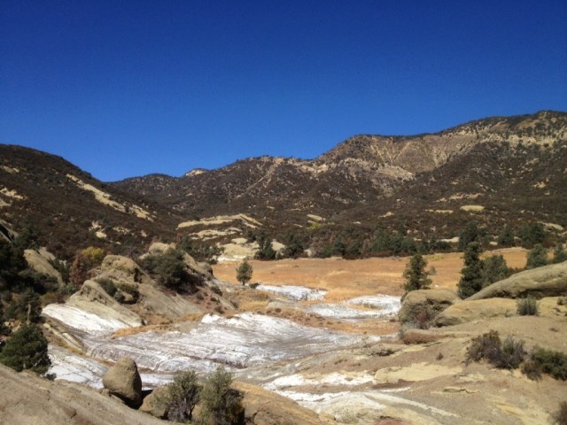
A place of this remarkable nature — a grassy flat with a mineral deposit, near a river once stuffed with steelhead trout, at the foot of pine capped mountains once teeming with game — seems like it would have been an attractive location in times past. It’s just a wild guess.
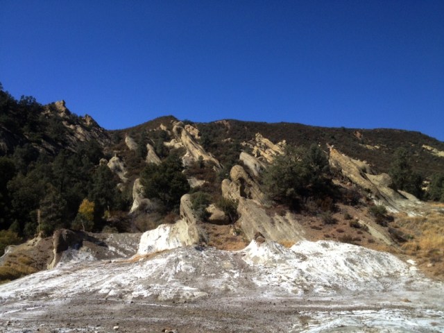
When I hiked through in 2011 I don’t recall the area being as salty as it was this last summer. Maybe because back during that particular season a lot of rain had fallen, 160 percent of normal county-wide up in Santa Barbara, and the minerals were diluted by abundant freshwater.
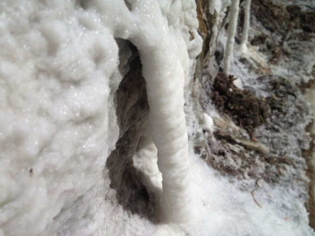
After several years of drought the crusty white buildup was much more extensive in late 2015, as shown in the snapshots. In some places the crystals were finely shaped and well-developed. Small puddles of extremely concentrated salt water pooled in the cavities of the rock that when stirred with a stick swirled like oil in water.
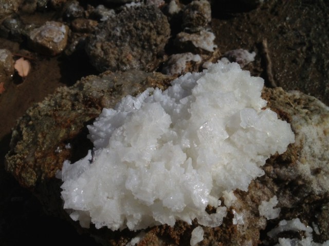
The word for salt in Barbareno Chumash is tip. Adding emphasis through reduplication signifies that there is a lot not just a little. Thus tiptip may be roughly translated as “lots of salt.”
“Goleta Slough was called tiptip, ‘salina, salt flat,’ and not surprisingly, the Ventureno equivalent sitiptip was applied to Hueneme lagoon,” Applegate writes.
Alternatively, sitiptip might be understood to mean “the place with lots of salt.”


Greetings… I looked for any previous comments, but didn’t find them… My query is this: these “salt” deposits…. Sodium Choride or Potassium Chloride? or some other variation?
I enjoy your blog… thanks…
Bruce Hake
Portland, OR
Hey Bruce. That’s a good question. I’m curious about what exactly it is, too. I’m not sure, and was using the term “salt” loosely to describe what ever mineral(s) it is.
I appreciate your posts Jack. I live over in the Matilija and often hiked over the divide into Santa 🎅 Barbara wildlands. Your words and photos resonate.
Thanks for stopping by, Ted.
Interesting thing about place names, the 1903 USGS Mt. Pinos topo doesn’t list the stream names or flats in the general area with the exception for the Sespe. On the 1942 topo the Sespe tributary names such as Munson and Burro appear for those drainages within the near-by area. At that time additional place names appear, Sandstone camp, Felt Ranch and Cherry Creek Campground. As some point there must have been some gypsum mining in the area with the addition of gypsum mine road. Perhaps this location this was the gypsum mine?
The area does contain some unique history. Did you notice the initials “ J. D. Reyes 1907 ” carved inside the ________ creek cave?
“Jacinto Damien Reyes served as District Ranger of the Cuyama District For 31 years and two months in what is now the Los Padres National Forest of southern California. J.D. Reyes entered the Forest Service in September 1900, and retired on October 31, 1931, at the age of 60.
Jacinto Damien Reyes was born in 1871 in San Buenaventura-by-the-Sea (Ventura), California, remained there through his schooling, then moved to his family’s ranch in Cuyama where he worked and lived for the next 43 years (near what is now the Los Pinos Ranger District of the Los Padres National Forest).”
http://www.foresthistory.org/ASPNET/People/Reyes/Reyes.aspx
“Gladiator Games of Bulls and Bears: Recollections of Jacinto Damien Reyes (1880)”
A bit more related to Gypsum Mine Road:
In the mid-1970’s the U.S. Gypsum Company made plans to extract phosphate from a 500-acre area in the Pine Mountain region north of Ojai. The U.S.D.I. Bureau of Land Management prepared an Environmental Impacts Statement on the proposal. Public hearings were held and the Sierra Club and other organizations, along with numerous members of the general public, attended the hearings and registered their opposition to the development of the mining operation. Denial of the permit was decided on because of the virtually unanimous regional opposition to the proposal for the strip-mining within the forest. (Blakley: 1985, pg. 86)
Jack, I’ve led several Scout service projects to this spot, always a fun time. We alternately call this canyon “Bunson” or “Yeso” (the latter due to the gypsum up-slope, which I believe is what contributes to the high mineralization). FYI don’t let 10-year-old Cubs sneak your water filter in an attempt to filter that water. Nearly ruined the element. 😉
Thanks!
Great story Jack. Always a pleasure to read your works.
I’m not terribly surprised you found this spot, I am little bummed it seems a few other know of it, but it is a good secret. I remember the first time I stumbled across this spot a few months before I left for college for the first time, I had no idea it was back up that canyon, I had been up that canyon to the cliff and the waterfall years before on my first quail hunting trip with my brother so it held some memories, but when i climbed over and saw the salt seeps that summer and the meadow, (there’s a little memorial in the far left corner above the deposits for a search and rescue member, or atleast it was there at the time) I have only been back one other time in the last few years and I saw a bobcat. I’ll always enjoy knowing this spot, and I’ll have to read over the comments as I saw some interesting info on it.
Always enjoyed your stuff Jack, I can’t wait to get back home to the los padres. I’d love to discuss some more areas with you sometime. Do you happen to know Otis, Paul Cronshaw or Rick Christensen?
I know the names, but not the people.