 Looking toward the Ko’onzi village site, the salt flats of Saline Valley visible in the distance beneath the snow-capped peaks of the Inyo Range.
“Saline Valley, Inyo County, California, is one of the most remarkable places in the state. . . .It is simply an immense basin, say twelve by twenty-five miles in size, surrounded on all sides by great mountains. At its lowest point of depression is found some 1,200 acres of pure salt–millions of tons of it, glistening like crusted snow. Bordering on this, on all sides except the west, comes miles square of sandy, dusty lands, caustic with alkali, borax or similar deposits.”
—Dallas Daily Herald (1882)
Saline Valley lies several hours drive from the nearest basic services and conveniences of civilization. Even today in 2017, even in the nation’s most populace state, this place is remote and desolate like few others.
The dirt road leading through the basin was horrendous at the time of our crossing, the washboards nearly debilitating in places, forcing a driver to slow to a crawl even in a 4×4 truck.
DavidStillman.com and I drove the dirt road into light snow showers and through an icy and treacherous narrow mountain pass to reach the valley, at one point having but mere inches to spare from plummeting some 80 feet into a canyon, when barely making it around a boulder that had rolled down onto the icy road. Mere inches to spare, I say.
Driving through the pass our view was short and narrow and cropped by the landscape and closed in beneath a low ceiling of cloud cover. One of the most remarkable experiences occurred as we rolled out of the pass. The hills broke open and Saline Valley suddenly fell out before us, a tremendous long view over the flats, a massive basin of open space that seemed to pull the breath from my lungs, to pull my body its way.
After the short views within the pass, the sudden long view over the valley was stunning (in the true sense of the word which is too often misused). It was as if I was enclosed in a room at the top of a skyscraper standing beside a door, which was suddenly opened to reveal that I was standing on the edge of the 100th floor overlooking a city far below stretching to the horizon. The sensation was not vertigo, but something akin to it.
On the edge of this salty basin, beneath ten thousand foot peaks, lies the Ko’onzi site. Here the ruins of single family shelters can still be seen in the form of circular-shaped stone footings. Nearby the rocks are decorated with petroglyphs, and a large erratic boulder beside the adjacent creek is dotted with mortars and painted with bighorn sheep pictographs rendered in ocher hues.
 Mortar stone with a view of the lake.
The indigenous place-name for Saline Valley was (is) Ko’, which means “deep place.” The people were called Ko’onzi.
The following describes and explains a bit about these environs and the people that once lived there, as excerpted from Julian H. Steward’s book, “Basin-Plateau Aboriginal Sociopolitical Groups” (1938):
“SALINE VALLEY–This district had an extraordinary range of life zones.
The deep valley floor, 1,200 feet, is in the Lower Sonoran Zone. It is mild in winter and almost unbearably hot in summer. It supports a little mesquite, but has few edible seed annuals, the majority of its sparse flora being extremely xerophytic and unfit for human consumption.
The bordering mountains, especially to the north and south, are in the Upper Sonoran and Transitional zones, where cooler temperatures make summer living possible and where greater precipitation supports many flowering annuals, which supply the greater part of plant foods. Pine nuts are also abundant in these mountains.
The high and massive Inyo Range which bounds Saline Valley on the west is too precipitous to be readily inhabitable but affords the greatest range of life zones. Better watered than ranges to the east, it supports many square miles of pine-nut trees. Its crest, however, extends above 10,000 feet into the Canadian and even Hudsonian zones, thus capturing greater precipitation, supporting a variety of flora, and feeding the one stream that reaches the valley floor. The vast area of the range and the greater vegetation maintained in turn many deer, which are largely lacking in ranges to the east, and large numbers of mountain sheep.
This remarkable variety of habitat zones and of species of both plants and animals within a comparatively small area enabled the Saline Valley people to maintain existence securely if not abundantly without having to exploit an inconveniently large area. …
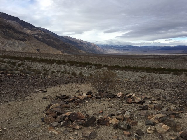
 The stone footings of two circular-shaped shelters.
 Two other ruins, the large white mortar boulder barely seen in the distance frame left.
The main village and division of the district was Saline Valley, Ko’ (deep place, descriptive of Saline Valley, which is very deep), elevation 1,200 feet. The people were called Ko’onzi. The village lay in the midst of a barren, infertile expanse of valley at the mouth of Hunter’s Canyon, where the stream maintains some mesquite and a few other edible plants.
Its inhabitants exploited the surrounding mountains, especially the Inyo Range to the west, where deer and pine nuts could be had. …
The Ko’ villagers obtained mesquite from the vicinity of their winter village. Other wild seeds, such as sand grass, grew in certain parts of the valley, but most seeds occurred surrounding mountains. Often they went into the Sigai country and other parts of the mountains separating Saline and Death Valleys.
Game, distinctly of secondary importance in Shoshoni economy but requiring considerable time of hunters, occurred largely to the north and west. Deer were procured in the Inyo Mountains, and antelope [pronghorn] in the lower ranges north of Saline Valley. …
Other foods were procured in various places but did not as a rule require extensive travel. Rats, mice, chuckwallas, rabbits, and birds could be hunted in all parts of the territory. Occasionally, however, trips were made, probably by single families, to Owens Lake for larvae or duck hunting.
Saline Valley yields great quantities of salt which was traded for goods or shell money to Owens Valley Paiute, who in turn often traded it across the Sierra Nevada Mountains.
Rabbit drives were held in connection with fall festivals. Usually people from throughout the district assembled for them. Sometimes, however, individuals took part in drives in the Koso Mountain or Death Valley districts.
BD said the Ko’ village as he remembered it about 50 or 60 years ago [circa 1888 or 1878] comprised five families or camps whose heads were as follows:
(1.) Caesar, the chief, (2) Caesar’s father, who had been chief before him, (3) Walkin, (4) Tom Hunter, the other chief, (5) Patu’ku. If, as in Fish Lake Valley, the average family consisted of 6 persons, the total population was not over 30 individuals.
 Trace remnants of a shelter ruin.
In later years of the historic period, long after the arrival of American explorers, the Ko’onzi were known for farming in Saline Valley.
While perusing old newspaper articles I happened across the following single sentence presumably describing the K’onzi.
The article was originally published on January 26, 1889 in the Pullman Herald out of Washington state.
“The Indians of Saline Valley, California, are raising fine fig, apple, pear and peach trees.”


Thanks for the post!
>
Very cool. Never heard of it. Thank you.
Great article/post. Makes me want to head toward Saline.
Dear Jack, I enjoyed the pictures very much. I’m 80 years old now and use to go to saline valley in June 1951-52 and 53. I was with an older fellow that had something to do with a mine nearby. It was west of the salt lake in the mountains. We stayed at an Indian encampment that had a family of 5. There was a large pool that was fed by stream from the mountain about 3+ miles away. 4-5 years earlier an air force bomber crashed into the salt lake. I was 12-13 and 14 years old an survived 125 degree +, lot of hiking & going into some mines. In those days was nothing like today. I met a fellow William Mann who wrote a book on Saline valley. Blm has closed off all west of the road. Just a quick note with a lot left in my mine. lol Anyway thanks for the pictures an research, Ray
Thanks for the comment, Raymond! Neat to hear.