
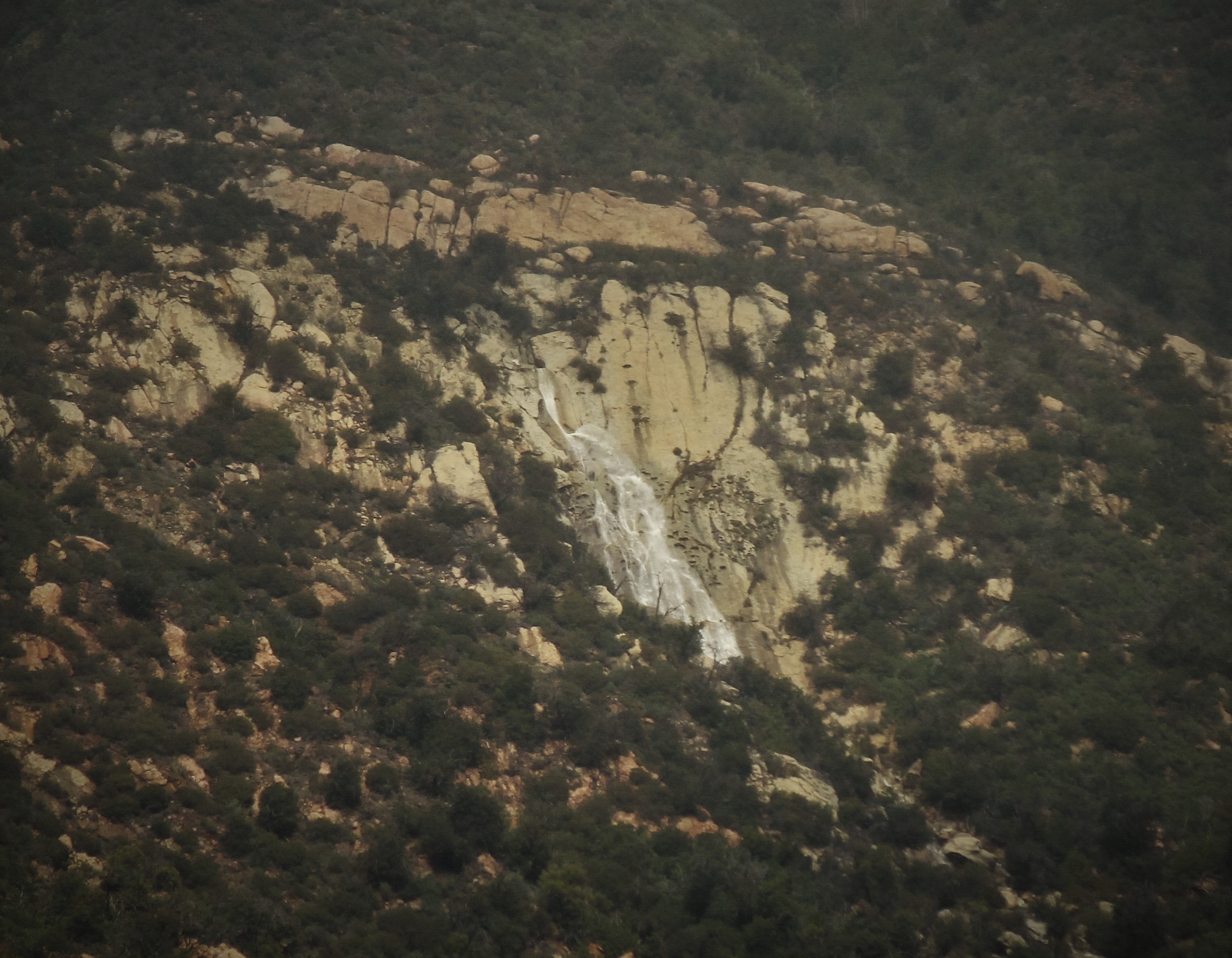
“Out around Glen Annie and Cathedral Oaks if you look toward the Front Range after a pretty good rainstorm you can sometimes see a tiny little set of falls that has a vertical drop of circa 100.’ It is set against an outcropping of rock and drains a quite small drainage. With good optics, it will appear as just a small thread of sparkling water and, if the wind is blowing, mist.
I’ve always known it by the name ‘Widow’s Tears.’ The name that old timers used…My main source for the name was Chuck Begg from a pioneer Goleta family. He pronounced it ‘Widda’s Tears.’
There seem to be a lot of Widow’s Tears falls around the US so I think the stories are probably apocryphal. After Chuck told me the name years and years ago, I heard it from other old timers.”
—woodman40 on SantaBarbaraHikes.com (2005)
Widow’s Tears is the one big waterfall, a cascade really, draining off the frontside of the Santa Ynez Mountains that’s seen from places throughout Goleta after heavy rains.
A blurb about Chuck Begg can be found in the Congressional Record (2002).
In an outcrop on the slope rising out of the steep and tumbling creek, not far above the falls, there is a cave with ocean and island views.
 The top of “Widda’s Tears.”


Incredible photography. Delightful narrative. Thanks again.
Jim Ansley, Iverson Ranch
Thanks Ansley.
Beautiful photos of the falls we so rarely see anymore. What a treat! Chuck Begg was my great uncle. I couldn’t find a blurb on him in this article though.
Hey Carrie. That’s interesting to hear. Regarding the blurb, look at the link I provided for Lois Capps’ comment. She commended him for his civic support and said he was “a treasure of the Goleta community.”
Thank you so much! Sorry it took me over a year to see your reply. lol Hope you’re doing well. I always look forward to your adventures.
I can see I feel from our house and always wondered where and what it was “thank you “!
Are the falls in the Bartlett Canyon drainage down from Arrowhead Spring, and did you access them from above or below?
Hey Frank. No, not below Arrowhead. This is below and just west of Lizard’s Mouth. That’s where I came down from. There is something of a use trail coming from Lizard’s that gets you down into the upper section of this drainage right below Lizard’s, and then it’s a creek scramble down to the falls.
I have a few pics of the falls from this January taken a short time after 2 to 3 inches of rain in Atwood’s hour period. How do you attach them to this comment format?
Thank you so much for the beautiful photos and explanation. Spectacular, really.
You bet. Always good to hear from you Lila.
A 2 to 3 hour period. (correction to last comment)
Have you ever tried climbing down the falls to the drainage below?
They are Widow’s Tears. They fall heavily at first, but they soon dry up.
Is there a hike by which you can access this?
You must hike down from the Lizard’s Mouth outcrop off Camino Cielo. It’s an unofficial and unmarked rough and rugged use trail. Not an easy hike.
Do you have a GPS pin of the top of the falls? I’m having a hard time determining exactly where it is–thanks!
It’s somewhere right about here:
(34.4911969, -119.8703898)
You have to find your way from around Lizard’s Mouth cave proper to this pocket of oak trees, which is in the drainage that leads down to the falls.
(34.4998122, -119.8705340)
Much of the way there is without a trail, through chaparral and scrambling through bouldered and brushy creek. When the water is flowing you must then also contend with that matter, which further narrows your options for less strenuous and discomfortable travel.
Thanks for a speedy reply!