Manzana Creek Schoolhouse (1893)

Manzana schoolhouse, Santa Barbara County Historical Landmark No. 2.

“I got paid $50 a month for teaching and paid $14 for room and board, and that was a shared bed at that, with at least one or two children.”

Cora McCroskey, at left, was Manzana schoolhouse’s first teacher

In the Santa Barbara backcountry, at the confluence of Manzana Creek and the Wild and Scenic Sisquoc River and accessible to the general public only by a long hike, there stands a schoolhouse established by nineteenth century pioneers. The following text is taken verbatim from a posterboard display located inside the old schoolhouse.

In the late 1800s, homesteaders from Kansas settled in the Sisquoc River Valley and struggled to farm the thin-soiled land along Manzana Creek and the Sisquoc River. By 1890, almost 200 people lived on 20 different homesteads in the valley. In March 1894, these settlers asked the Santa Barbara County Board of Supervisors to establish a local schoolhouse. Classes began on the 4th of July of that year. Classes were held in the summer months when the river was low enough for the children to cross safely. The schoolhouse also functioned as a community center for social gatherings.

Teachers lived with local residents or rode on horseback or by wagon to the schoolhouse. Seven different instructors taught during the school’s short existence. Eventually, the weathered turned against the settlers and dry years made both farming and cattle unprofitable. Settlers moved away. In 1902 with only one student enrolled the school closed.

The schoolhouse was abandoned for several years, until two fur trappers from Lompoc moved in and set traplines along Manzana Creek in 1927. They used the building as a large drying rack for their pelts. One of these men trapped animals in the Sisquoc-Manzana area for about sixteen years until his death on Figueroa Mountain. Following World War II, the structure was used by campers, hikers and hunters. Ranchers even stored hay and salt inside the building for their cattle.

In 1966, the County Landmark Advisory Committee designated the old schoolhouse as the second Historic Landmark in Santa Barbara County. In 1988 a full fledged restoration project was initiated, a cooperative effort between the Los Padres Interpretative Association and the U.S. Forest Service. Such projects point to the need for protecting our cultural resources, while preserving them for the future enjoyment of others. Please help in this effort.

A detail of the pine planks making up the outside walls of the schoolhouse, which are riddled with holes from wood peckers.

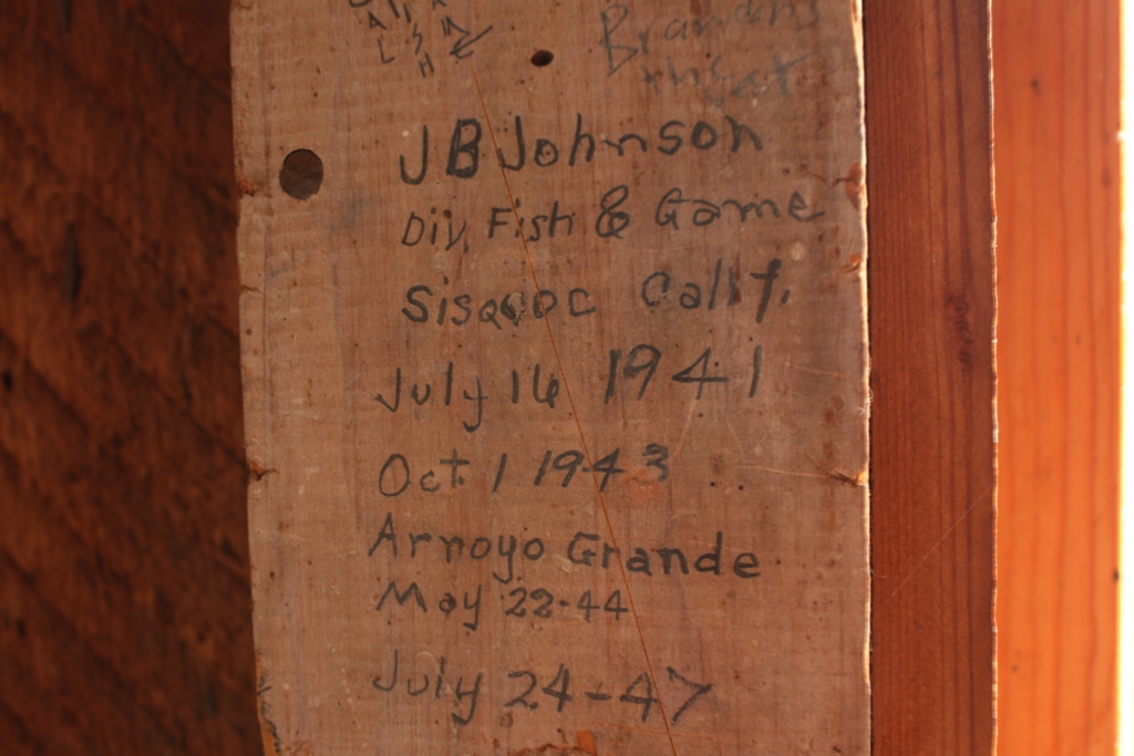
The inside of the schoolhouse is covered in one hundred years worth of names and dates that have been written on and carved into the walls. While the older dates I find intriguing and view with pleasure as a piece of history, the newer ones make me cringe and even give rise to anger. It’s a contradiction of sorts I have long pondered and have yet to resolve.

The old black board inside the school was long ago turned into a free-for-all graffiti panel. R.L. Cooper carved his name and the date into the soft wood back in 1911 and one hundred years later, long after the building was officially designated a Historical Landmark, lamebrain Lars Peterson added his mark.

Posted in Santa Barbara County | Tagged , , , , , , , , , , , , , | 15 Comments

Potrero Canyon, Hurricane Deck, Manzana Creek 20 Mile Day Hike

The circuit I hiked noted on Bing imagery.

I woke early and hit the super slab driving up over the Santa Ynez Mountains, across the Santa Ynez Valley and over Figueroa Mountain to the lower Manzana Creek trailhead in the San Rafael Wilderness. In preparation for getting my arse kicked out on the trail by this suicyco mutha***** I’m soon to do some hiking with, I spent eight hours, plus an hour lunch break, hiking over 21 miles of trail and no less than 4500 feet in combined elevation gain and loss.

Despite the length, the loop is a relatively easy walk as most of the trail is fairly flat apart from the climb up Potrero Canyon to Hurricane Deck and back down to Manzana Creek at its confluence with the Sisquoc River.

As the morning waned the sky cleared to pure blue but with cool winter temperatures. I hiked all day in a short sleeved t-shirt under a long sleeved shirt. Not much wildlife this time around. I only saw a few deer, couple of hawks, a small snake and three turkeys.

A section of west Hurricane Deck in morning light, the red dots noting the trail route. The more prominent grassy face of Bald Mountain is seen rising just beyond the Deck with the Sisquoc River canyon in the background.

A panoramic iPhone camera shot from atop the west end of Hurricane Deck and looking over the Sisquoc River canyon at center frame. Castle Rock can be seen on the left along the ridgeline. The trail follows the crest of the ridge by Castle Rock and then descends to the Sisquoc River and Manzana Creek confluence.

Looking up stream on the Sisquoc River from Hurricane Deck. It’s rugged, unforgiving dry country that is still making a recovery from wildfire.

A view of Castle Rock showing the burnt, barren hills of the San Rafael Mountains.

Castle Rock

A riverside meadow or what the Spaniards called “potrero.”

The slit in the rocks above Manzana Creek.

This rusty remnant of a tractor or tiller of some sort sits in a meadow along Manzana Creek. A stacked rock wall is nearby and judging by the lichen covered stones it appears old. Knowing next to nothing about old farm equipment, I would hazard a guess that, judging by the wheel design, this piece of machinery is from the Depression-era.

Here below is a series of clips captured along the hike and slapped together. It was shot with an iPhone and so the imagery is poor, pixelated and pretty rough, but, nonetheless, it offers a bit more of a peep into what the day was like through my eyes.

Posted in Santa Barbara County | Tagged , , , , , , , , , , | 13 Comments

The Death of Happy Jack (1879)

A photo of a whiskey lovin’ drunk circa 1907.

Nineteenth century police blotter from the Ventura Signal newspaper, March 1, 1879:

Daniel Collins, commonly called “Arizona Jack,” or “Happy Jack,” died at Saticoy on the night of the 25th of February, from an overdose of whiskey. It appears that during the day he went into Morris Cohn’s store at Saticoy, to beg a dring (sic) of whiskey. Cohn gave him a beer glass filled with the poison, which he drank, enough to itself kill an ordinary mortal. But he was given two more glasses by Mr. Cohn, which he drank in rapid succession. Overcome by the liquor he immediately went and laid down, and expired about 10 o’clock in the evening. Mr. Cohn cannot be too severely criticized for his lack of judgement shown in this matter, although in all probability he meant no harm in giving the man the whiskey, still he ought to have known better. Such trifling is most dangerous.

Related Post:

Tarantulas and Whiskey

Posted in Ventura County | Tagged , , , , , , , , | Leave a comment

The Carrizo Experience: Ten Hours on the Plain IV

This post is the fourth and final installment in a series.

Read the first here: Ruminants on the Range.

The second here: The Bedrock Mortars of Selby Rocks.

And the third here: The Pictographs of Painted Rock.

An aerial view of the salt flats on the Carrizo Plain National Monument known as Soda Lake (Jack’s Map). The photo shows the salty white expanse of the lake bed when dry and some of the numerous branch channels draining from the plain. (Image courtesy of U.S. Geological Survey)

The Salt Flats of Soda Lake

Every crunchy footfall explodes in a white cloud of salt, as I pick my way through the maze of tributaries that vein the grassland around the fringes of Soda Lake. I wander by scattered pieces of old sun-bleached, salt-crusted lumber along with several coils of rusty barbed wire. Walking across the crispy grassland surrounding the shoreline, I step into a dry channel to cross and my foot falls silently into several inches of super fine, fluffy dust that feels like powdered graphite beneath my feet. It makes me think of walking on the moon.

The branch channel, which drains into a smaller basin adjacent to the main body of Soda Lake, has a dirt bottom rather than the hard crusty saltpan typical of the larger ponds. Small animals have pounded narrow, hardened trails into the deep powdery silt in various places and occasional hoof prints mar the otherwise smooth textured duff. I pause to consider a series of tracks wondering if they were left by deer or antelope. They are too small for tule elk. Turning slowly about in a full circle I see no signs of any animals but their footprints and no trace of civilization. A quiet stillness blankets the desolate land.

Every footfall explodes in a puff of white salty dust.

Much of the Soda Lake complex of channels and basins is hidden from sight. It sits below the level of the plain and is thus invisible from afar. It is much larger than I had previously thought. When wandering around the area I cross numerous channels leading toward the lake, which materialize in the ground suddenly and for seemingly no reason. The barren ditches point like crooked arthritic fingers into the flatness of the grassy plain, depressions created through saturation of the lowlands and the resulting slight flow of water down an imperceptible slope.

I come to one dry dirt-bottomed basin with three sets of animals tracks crossing it. Two of the tracks join together on my left and cross the lakebed in a single straight line, while a third set drifts at an angle rightward before making a beeline to the far side. Finding a bit of humor in the animal sign, I mockingly leave my own tracks.

Long before reaching the edge of Soda Lake I see it is dry or at least not full of water. The lakebed along the shoreline is covered in a ceramic-like layer of saltpan, but gives slightly under foot. The farther I walk toward the center of the lake, the less developed the salt crystals, the thinner the layer of saltpan and the softer the soil. Until it no longer holds my weight and I begin sinking into the mire.

A gooey black sludge reeking of decomposed organic matter makes up the lake bottom. Were it not for the salt it would make an incredible compost for gardening. Atop the black sludge is a thin layer of brown soil that is, apparently, the result of wind blown debris accumulating in the basin. The saltpan forms on top of the layer of soil as the water evaporates.

Retracing my footprints back through the complex of alkali flats as the sun drops close to the horizon, the temperature falls noticeably and the land feels even more lonely. I feel like a lone hominid in a primordial age wandering the shore of a prehistoric sea.

I take comfort in the bleak isolation. Walking into the short grass of the plain a bit away from the salt flats, I lay on my back with eyes shut and attempt to sense without sight my surroundings. It is an exercise that provides a different sense of reality compared to what I have encountered through out the afternoon with eyes leading my way and, for the most part, dictating the terms of my experience.

I drive down the dirt lane of Soda Lake Road peering through the mottle of dust, dried dog slobber and nose prints covering the windows of my vehicle. The time is right for spotting grazing antelope, deer or elk, but scanning the vast plain there are none to be seen. Sensing that it’s time get moving on home I increase my speed down the dusty road. The clouds reflect the last vestiges of solar radiance and burn brightly in the darkening sky, as if to bid a warm farewell as I head toward the long winding mountain road home.

Related Posts:

Summertime Soda Lake

Soda Lake Winter Reflections

Posted in San Luis Obispo County | Tagged , , , , , , , , , , , , , , | 2 Comments

Valley Oak in Winter Light

A California valley oak (Quercus lobata) standing along Happy Canyon Road in Santa Barbara County.

Posted in Santa Barbara County | Tagged , , , , , , | 7 Comments