The Mighty Chia Seed, Cuyama Badlands

cuyama-badlands-dome-springs-hike

The Cuyama Badlands can be a wicked and terrible place for a human on foot with minimal supplies. Heaved aloft, scorched and desiccated, it’s a land clawed open and washed away by spotty cloudbursts that quench a sparse growth of piñon pine, juniper and sagebrush.

Barren hills pushed upward through thin forest like a balding head pushing through thinning hair. Deep rain-carved wrinkles, tall and thin wavy fins and ruffles hint of hills melting imperceptibly raindrop by measly and hardly ever seen raindrop into the piñon flats below. Hillsides of ocher-colored cobblestones piled as if dropped by dumptrucks.

How long with so little rain to wash the stones free and clean of nearly every grain of sediment that once entombed them? How long to form the cement-like, crusty hard sedimentary fins of eroded badland terrain that rise above the ground taller than a person’s head, forming deep and narrow troughs?

cuyama-badlands-hikes
cuyama-badlands-hikes-vantura-county-los-padres cuyama-badland-hiking-campingchia-seed-bloomA spent chia bloom full of seeds.

“Good-tasting and satisfying, chia was highly regarded among every Native American group in whose territory it occurs.”

Jan Timbrook, “Chumash Ethnobotany: Plant Knowledge Among the Chumash People of Southern California”

August can be hellish, but the day is mild. I rest comfortably on a hillside in the desert sun rather than hiding in tree shadows from the fireball overhead.

The bad land and sparse forest before me feel more like Arizona or New Mexico than California. Indeed, a nearby arroyo takes its label from this variety of drylands, “Apache Canyon.” It’s appropriately named. Venturing into these canyons is like traveling into the American Southwest though they’re only a short drive from Santa Barbara in neighboring Ventura County.

Despite the land’s deathly appearance and harsh climate, a remarkable small flowering plant grows here that was once vitally important to prehistoric humanity, including the Chumash Indians for which a nearby wilderness is named. This is the chia seed producing Salvia columbariae.

The Chumash would roast the seeds, grind them into flour and then mix the flour with water to create a drink, chia pinole, that was “a good thirst-quencher,” Timbrook writes. Using less water in the mix, they also made a thick gruel or paste that was dried into small cakes. The cakes could be saved for later or carried into the field on outings.

Wandering a random animal trail along a ridge I come across a stand of crispy brown chia plants which bloomed and died months ago. Yet, a quick shake of a stem sends shiny seeds flying. The seeds have remained sheathed in the protective husk of the spent bloom through months of summer swelter.

The old blooms stand in the air on thin stems like packets of a highly nutritious snack on the shelves of nature’s grocery store. Within a couple of minutes I gather several handfuls. The tiny kernels have an exceptional flavor, far superior in my opinion to the store-bought variety. I eat the free and natural energy-packed snack by the handful savoring the nutty flavor.

chia-seeds-salvia-sageFreshly harvested chia seed.

The word “chia” derives from the Nahuatl language of the Aztec. “The seeds of the chia plant were such an important part of the Aztec diet,” Keoke and Porterfield write, “that they were brought as tribute to the capitol city, Tenochtitlán. . . .The effects of chia’s nutritional potency were legendary. Aztec warriors and hunters lived on chia seed in the field.”

Commenting in jest to emphasize the point, Christopher McDougall writes:

“In terms of nutritional content, a tablespoon of chia is like a smoothie made from salmon, spinach, and human growth hormone. . . .If you had to pick just one desert-island food, you couldn’t do much better than chia . . .after a few months on the chia diet, you could probably swim home.”

“The Hopis fueled themselves on chia during their epic runs from Arizona to the Pacific Ocean,” McDougall writes. “The Mexican state of Chiapas is actually named after the seed.”

In his book, “Born To Run,” McDougall writes of the Tarahumara Indians of northern Mexico whose diet includes chia. The Tarahumara credit the seeds for helping them achieve mind boggling feats of physical endurance.

The men of this tribe are widely regarded as some of the world’s best long distance runners. In traditional times their hunters ran down large game on foot, chasing deer until the animals dropped of exhaustion and could no longer so much as walk to escape.

cuyama-badlands-landscape

“The Tarahumara keep the deer constantly on the move. Only occasionally does he get a glimpse of his quarry, but follows it unerringly through his own canny ability to read the tracks. The Indian chases the deer until the creature falls from exhaustion, often with its hooves completely worn away.”

-W.C. Bennett and R.M. Zingg, “The Tarahumara: An Indian Tribe of Northern Mexico” (1935)

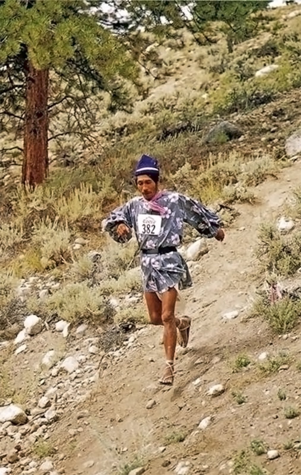
Victoriano Churro of the Tarahumara set a world record for the ultra-marathon in 1993. At age 55, he ran 100 miles through the mountains of Colorado with 20,000 feet of elevation gain/loss in just over 20 hours.

He finished 40 minutes ahead of his nearest competitor.

Still not impressed? Try this on for size: He made the record-breaking run while wearing “huarache sandals homemade from old tires and leather.” (See a photo of Churro running down a mountain in sandals.)

cuyama-badlands-painted-hills

Chia seeds contain all essential amino acids and are about twenty percent protein, which notably comes in a nutritionally complete form. The seeds are also about twenty percent fat and high in fiber. These components combine to provide a remarkable level of essential nutrients that fuel sustained energy. These days the tiny kernels are often called a “super food.”

Two tablespoons of seeds provide about 6 grams of protein, 8 grams of fiber and 8 grams of fat along with 120 calories. By contrast, a Clif Bar offers about 9 grams of protein, 3 grams of fiber, 3.5 grams of fat and 240 calories.

If available in nature’s storehouse along a hike, four tablespoons of seeds will outperform that dense wad of Clif Bar, and do so without added sugars and artificial foodstuff like “soy protein isolate” that’s concocted in a laboratory by scientists.

In addition, chia absorbs many times its own weight in liquid, which is thought to help maintain hydration and electrolyte levels longer during physical activities when the seed is eaten with water. For the hiker of hot weather and drylands this hydrating characteristic is invaluable.

Interesting that this plant often grows in these sorts of dry places, one of many cases of nature providing something of a solution on one hand for a problem it presents to humans on another. Sort of like medicinal mugwort growing beside noxious poison oak.

Even if a hiker doesn’t care about scoring the nutrients for added energy without having to carry it, a couple handfuls of seeds quickly harvested along a trail could do wonders for keeping them hydrated, and thus lessen their need for water, which in turn could mean lugging less weight in their pack.

Knowledge and skills weigh nothing and take up zero space in a backpack. What a person carries in their head they need not carry on their back nor buy at the store.

Posted in Reference | Tagged , , , , , , , , , , | 7 Comments

Scotland, Shifting Baseline Syndrome & Your Local Wilderness

Goatfell Peak Isle of Arran Scotland hikingGlen Sannox as seen from Cir Mor Saddle, Isle of Arran, Scotland. Such scenic sweeping grassland is not natural, but in fact the result of human agency.

“The British Isles, a Roman outpost located at the edge of European civilization, was covered with timber at the beginning of the Middle Ages. All who came to the British Isles unrelentingly pressured the woodlandsthrough unrestricted grazing by pigs and cattle, unrestrained logging for charcoal (used to smelt iron) and for building timber, and wide-spread clearing and burning of forestland to create pasture. By the end of the Middle Ages, Great Britain had been largely stripped of its native forests, except for patrician hunting preserves.”

Max Oelschlaeger, “The Idea of Wilderness” (1991)

“Since the Second World War, sheep have reduced what remains of the upland flora to stubble. In 6,000 years, domestic animals (alongside burning and clearing for crops and the cutting of trees for wood, bark and timber) transformed almost all the upland ecosystems of Britain from closed canopy forest to open forest, from open forest to scrub and from scrub to heath and long sward. In just sixty years, the greatly increased flocks in most of the upland areas of Britain completed the transformation: turning heath and prairie into something resembling a bowling green with contours.”

—George Monbiot, “Feral: Rewilding the Land, the Sea, and Human Life” (2014)

I would like to step back to a previous post, Goatfell Peak, Isle of Arran, Scotland, to discuss environmental degradation and how people sometimes misinterpret the land they see before them.

In his book, “Feral,” Monbiot writes about how some people in Britain have forgotten, or never learned, that the land there was once heavily forested and populated by wolves, bears, lynx, wildcats, boar, beavers, loads of birds and other creatures common in woodlands.

With the clearing of the forest so went the wildlife. And nowadays, “the open, treeless hills are widely seen as natural.” But, he writes, “what we have come to accept as natural is in fact the aftermath of an ecological disaster—the wasteland that has replaced a rainforest.”

What’s more, he elaborates on how, incredibly, conservationists have worked to maintain the wasteland as if it was natural and pristine rather than the butchered remnants of a once thriving and diverse forest ecosystem.

Goatfell Peak hiking Scotland Macrie MoorDenuded valleys and hills. Glen Rosa as seen from Goatfell Peak.

As I hiked to the summit of Goatfell Peak, along its ridgeline flank toward Cir Mhor Peak, and down into and through the entire length of the Glen Rosa valley, the most remarkable wildlife I saw was a black slug, a caterpillar and a few small trout. It was, despite its seeming beauty, a wasteland with little apparent life apart from its low plant cover.

The land had been stripped of its native forest and mowed into submission by grazing sheep. An exclosure fence had been installed in Glen Rosa to keep the sheep out of an area selected for protection so as to be allowed to regrow native flora.

In all the valley only a few small trees remained clinging to a few rocky, steep nooks on short cliffs above the creek, inaccessible to the ravaging ruminants. Much of the land, as evident in the photos here, resembled the bowling green with contours Monbiot describes.

black slug Arran Acotland

caterpillar Arran Scotland

Monbiot references a phrase coined by Daniel Pauly, “Shifting Baseline Syndrome,” to describe the general public’s lack of historical context when assessing the health of their wildlands.

The idea is that each generation bases its notion of what are normal and natural environmental conditions on the state of the land they have experienced during their own short lifetime.

Without a proper understanding of what the land once was as based on past conditions, and with ever greater environmental degradation through subsequent years, the bar is consistently lowered from one generation to the next. Hence the baseline for what is considered normal, natural and healthy ecosystems is ever shifting, falling lower and lower and lower.

The result is that we can look approvingly, and I mistakenly have, upon an environmental disaster and describe it as being stunningly beautiful, because we lack the historical perspective that dramatically proves otherwise.

Glen Iosa Arran ScotlandLooking down Glen Rosa.

“The objective is to teach the student to see the land, to understand what he sees, …”

–Aldo Leopold, “The Role of Wildlife in Liberal Education” (1942)

I encourage readers to take the notion of Shifting Baseline Syndrome into consideration when viewing the wildlands where they live, and to try to understand what they are actually, really seeing before them. To see and analyze what they are looking at through the prism of history and to use that as a baseline in assessing the health of the wilderness in their own wild backyards.

Consider the possibility that what may seem sublime, beautiful and scenic at first glance, may in fact be highly degraded habitat or an outright environmental disaster that has been normalized by a shifting baseline, where the standard of quality, so to speak, creeps ever lower through each subsequent generation but goes unnoticed.

It is important to understand how much has been lost if we ever expect to replenish and revitalize the wild world to anything remotely close to what it once used to be, long before our own birth.

We can’t possibly hope to rebuild what we aren’t even aware once existed.

Glen Iorsa Arran ScotlandLooking up Glen Rosa at Cir Mhor Peak.

Posted in Scotland | Tagged , , , , , , , , , , | 10 Comments

A Great Interval of Silence, Chumash Wilderness

campfire cookingBoilin’ the billy.

“Great intervals of silence are evidently conducive to our well-being. A meditative stillness, suggests Gary Snyder, was invented by waiting hunters. Perhaps this reflected the poised and ruminating hush of mothers of sleeping infants. High levels of sound have been directly linked to degenerative diseases in urban life.”

Paul Shepard, “A Post-Historic Primitivism”

I rolled slowly down into Quatal Canyon toward Cuyama Badlands, the crunch of wheels on a gravely dirt road. Passing Toad Springs Campground, I cast a casual glance over my left shoulder at a grizzled and greasy man hanging thin sheets of raw beefsteak over a wire fence.

We locked eyes for a second as I passed. What a look. What a mug. A good face for an artist to render in woodcut. Scruffy and tanned and weathered and creased and glistening in the late afternoon mottled light of the forest, a character out of a Clint Eastwood spaghetti western.

Jesus, I thought. What the hell is that psychopath up to? He might have been thinking the same of me. His piercing gaze and the hanging flaps of raw red meat, a primal scene. I was trying hard to step back in time, into the primitive realm of the undeveloped world let alone by humanity. “Seldom used,” Craig Carey wrote of where I was headed. Perfect. And this strange man appeared like a sign post in the forest hinting that I was traveling in the right direction, maybe.

I kept rolling deeper into the shadowy woods, farther from all others and the incessant noise of civilization. Onward forth toward the great soul-soothing silence of wildness.

Chumash WildernessTrail along foothills of Mount Pinos.

The trailhead was unmarked, which seems fitting for the southern Los Padres National Forest, where official hiking trails are often signless, overgrown, difficult to find, and not easy to follow if located. “Navigating for the correct trail can be a bit tricky,” Carey wrote.

An article appearing in the Los Angeles Times in 1990 described different portions of this trail as “the unsigned trailhead,” “unsigned Mesa Spring Trail,” “an unsigned trail junction,” and “a (poorly) signed trail junction.” Twenty-six years later it remains much the same, fortunately. I saw the sign for the camp on the ground last I was there a few years ago. I didn’t see it there this go around.

There is enough room for two vehicles to park off the dirt road at the trailhead, maybe three can fit with skill. Without four-wheel drive, and the sort of driving ability and gusto for risk that usually accompany such vehicles, the parking spot here might best be described to the average driver of a car as, “Wait, what? I’m really supposed to park there? You’ve got to be kidding me!” It wouldn’t take much to get stuck.

Cuyama Badlands San Emigdio ChumashTrailside view of Cuyama Badlands.

On the way out of town I stopped at the beach and surfed for hours, lured and distracted by a good winter swell. I reached the trailhead late in the afternoon and the sun had nearly set. It was impossible to hike to camp before darkness swallowed the land.

Half an hour after walking away from my vehicle I left the trail. I stepped carefully through breaks in the scrub oak and spotty tangle of brush so as to leave as little trace as possible in the delicate dry habitat.

I found an opening of gravelly soil surrounded by scrub and accented with a single piñon pine. I spread out my bedroll, set alight a small pile of thin branches and twigs, pushed my can of water aside the dancing flame to boil, and laid upon the earth to watch the sunset colors peak and fade to black.

The next morning I scooped up the small pile of powdery ash and scattered it about the area beneath scrub oaks. Scraping up a bit of soil from here and there under the brush, I sprinkled it over the burn site for concealment and then topped it with a dead branch lying nearby. I left only footprints visible as I marched away toward Mesa Spring in the cool morning light.

Cuyama Badlands San Emgdio hikes

I laid in the shade at camp listening to the ebb and and flow of wind through trees.

I wandered through miles of piñon forest, walked San Emigdio potrero, and strolled aimlessly along differing lengths of different trails searching for something I never lost, something nobody had ever left behind, something that most people have no interest in and do not value. What it is I’m not sure. I never found it. The search will continue.

In the mornings and afternoons I sat on a slope along the foothills of Mount Pinos, overlooking the forest of piñon pine backed by Pine Mountain Ridge in the bluey distance.

For three days I watched intently the timeless show rendered in pacific hues of green and blue, tinged orange yellow and red at dawn and dusk, the calming low desolate murmur of wind blown pine needles the soundtrack.

I saw nobody; the sort of body a body like me likes to see when enjoying the medicinal qualities of a great interval of solitude in the woods.

I felt a million miles away from all that is said to matter in the metropolis, alone swaddled in the great therapeutic silence of wildness; salve for the soul. If somebody jarred the feeling I’d be a buyer, maybe even a junkie.

“What is there to do out there?” Somebody may ask from the crowd that constantly demands the throbbing pulse of instant gratification, and the glittering, overt, up-in-your-wide-eyed-face smash of Las Vegas-like stimuli. “Here we are now, entertain us,” Kurt Cobain said.

Nothing. Nothing at all. There’s nothing to do.

That’s the point.

Chumash Wilderness San Emigdio

San Emigdio hike

San Emigdio MesaA green-tinged San Emigdio Mesa in February.

Chumash Wilerness campMesa Spring Camp

Chumash Wilderness San Emigdio Los PadresSunset colors from camp.

Posted in Ventura County | Tagged , , , , , , , , , , | 13 Comments

A Wander In Hawaii Turns Up Ancient Rock Shelters

image
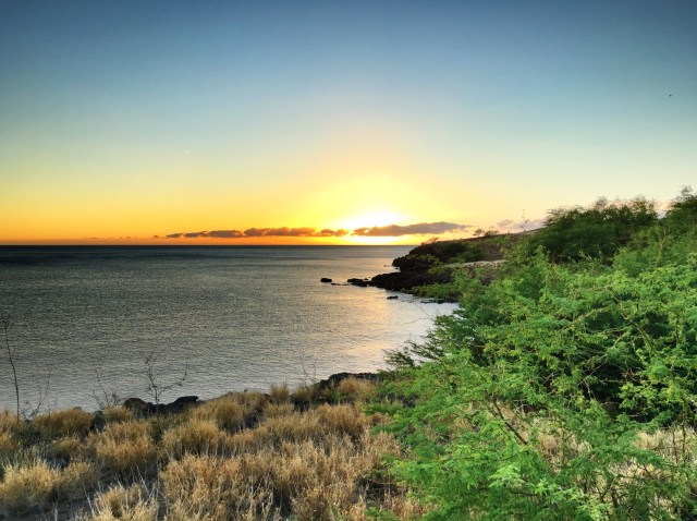
The dry wash described below lets out into this small cove on the lee side of the point.

“Where you off to?” she asked.

“I saw a big crack in the Earth just down the road that looks like it needs to be explored,” I said.

image
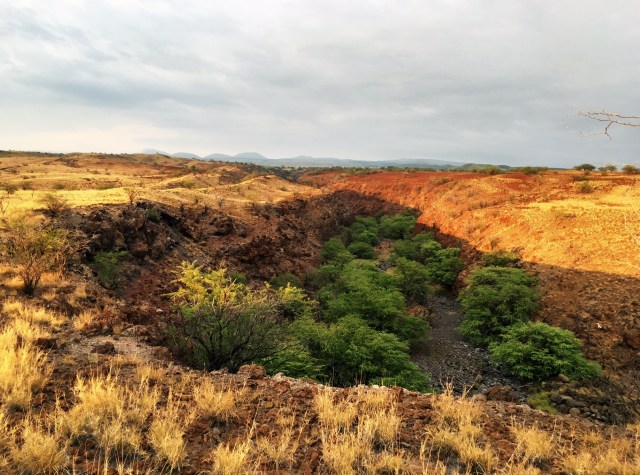
Looking over the dry wash from above. Shortly beyond the last visible trees the canyon narrows into a gorge.

We had just returned from a six hour road trip and I desperately needed to get out. This dog needed to be released from the kennel and unleashed for a run.

One might question how a six hour drive could possibly be called a road trip. It’s a fair question. I have a good reason.

Spend five hours locked in the van with two four year olds and a seven year old with nothing to do, with but an hour break for lunch, and you’d call it a trip, too.

I drink little and infrequently, and rarely ever order a cocktail let alone in early afternoon and never with lunch, but this day I ordered one. “Oh wait,” I said as the waitress started to walk away. “I need some liquor.”

Suffice to say our day hadn’t gone according to plan due to approaching tropical storm, Darby. We essentially drove for six hours to eat lunch. We never made it to Volcanoes National Park. Damn right I was ordering a drink!

Fortunately the Mai Tai had hit like a mule kick and took me out of commission. Yeah, I know, I’m a real lightweight. Leveled by a single drink. My only defense is to say that it was stiffer than the British upper lip in WWII.

The drink helped to relax and soothe my frayed nerves, but also resulted in the Mrs. taking over driving duty. This in turn gave me the opportunity to gaze out the window, that had then resulted in my having spied that aforementioned big crack in the ground.

image
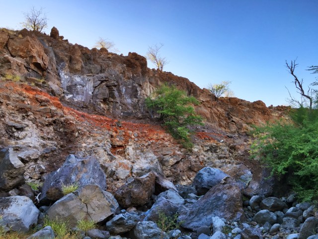
The ragged and rugged scene while hiking up the canyon.

That crack was really a chasm that had been carved deep into the lava rock by heavy rains that fall high up on the slope of Kohala (5,505′). Passing over a short bridge at speed, I had caught a glimpse of this small red-walled canyon filled with the green canopy of kiawe trees (Hawaiian mesquite). It winds its way up the slope of surrounding desert-like dry rolling grassland and narrows to a gorge. It looked too appetizing to be left alone. “No way,” I muttered to myself. “Wow.” I was compelled to go.

I stepped cautiously in my flip-flops down into the wickedly spiny forest of kiawe filling the canyon and had walked about forty yards up the dry creek bed from the beach when I saw it.

image
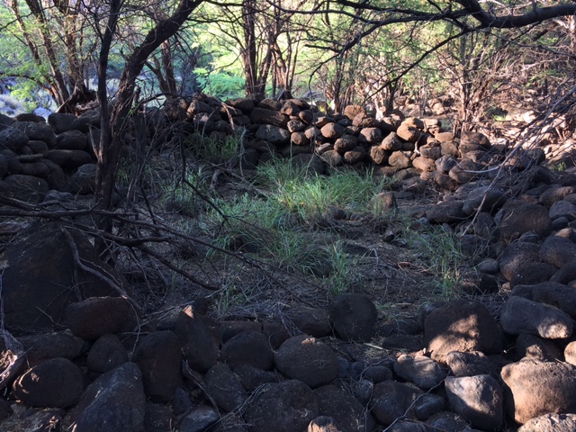
The ruins were hard to capture clearly in a photo, but look carefully and the circular shape of a stacked stone design should be visible.

There on a bench beside the wash, above flood level, was a large circular-shaped group of boulders. It resembled an old stacked stone wall enclosing an open space within where a patch of grass grew and it stood about three to four feet tall.

There was no question in my mind when I saw it that it was something of archaelogical significance, though it should be noted that I am not a trained expert and nor do I have confirmation by an expert. But what else could it be?

Many if not most of the boulders were too heavy for one man to lift and would require at least two or more people to move and arrange. It was not the sort of creation I would imagine modern people to have built for it clearly required a great deal of strenuous work and many hours. It was not some beach hut thrown together by modern locals at their favorite spot to hang out at.

image
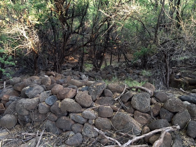
Looking at same ruin from another angle.

image
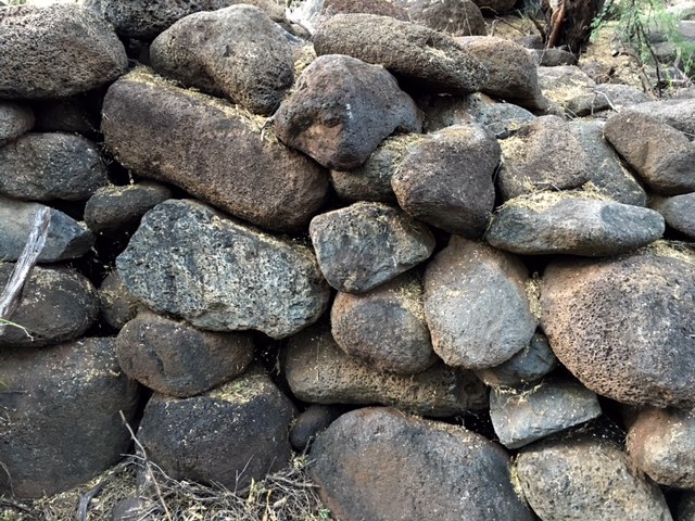
A closer view of the stacked stones.

image
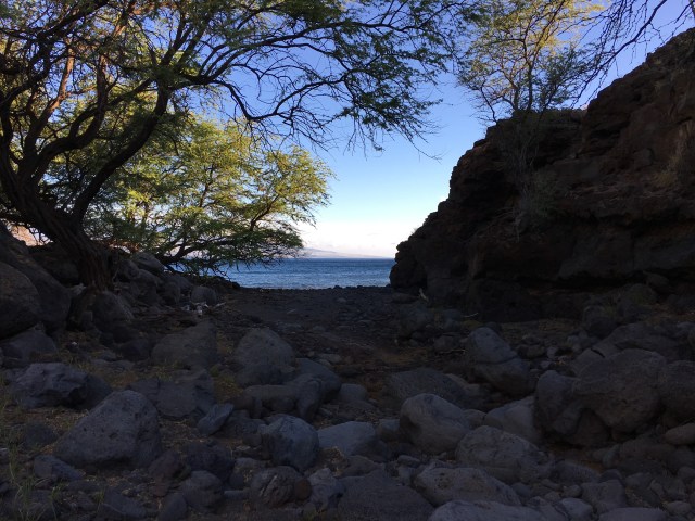
Looking out the mouth of the dry wash to the ocean.

The site seemed well-suited for a camp. It was tucked back in the narrow canyon away from the immediate seashore and was sheltered from wind by forty to fifty foot sheer cliffs on either side. The mouth of the dry wash drained into the sea on the lee side of a small point and was protected from the prevailing winds. The location allowed for quick and easy access to the ocean for fishing or whatnot.

In the preceding days I had been freediving in the area nearby popping scallops from the rocks. My brother-in-law, a native Pacific Islander born on Hawaii, had introduced me to his friend who had shown me a photo of a thirty-five pound ulua he had recently shot nearby while spear fishing. They had told me of a man having disappeared last year while spear fishing not too far away, presumably due to a shark attack (link to story here). They told me about another guy who, four days later, survived a tiger shark attack while spear fishing in the same area (link to story here). I had also been told that in winter humpback whales pass by this place hardly more than a stone’s throw from the beach. Not that anybody needs one line anecdotes to appreciate that these coastal waters of Hawaii were (are) exceptionally rich, but this area probably wouldn’t have been a poor choice to camp in prehistoric times.

image
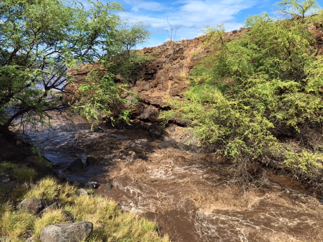
Twelve hours later the formerly dry wash was raging, the eerie thud and crack of boulders being swept to sea, which is just visible here through the trees frame left.

The wash, while relatively small, was one of the more significant drainages in the area; a fact that was confirmed early the next morning when, after a night of heavy rain on the mountain, the formerly dry creek bed was a torrent of runoff that pushed a fluvial discharge of muddy water far out into the sea for several hundred yards.

No other such plumes of runoff could be seen along the coast anywhere in the immediate area. It was remarkable enough that it even caught the eye of my four year old son who pointed it out. Two days later the wash was empty again but, standing on the edge of the canyon high above, I could see a few pools of water dotting the otherwise dry creek bed. The silt had settled and the pools were clear; plenty of water to slake the thirst of the ancient ones who may have lived there.

imageOne of the other ruins, which appears far more distinct when standing before it than it looks in this photo, but the circular shape should be evident.

After spotting that first circular stand of boulders I began scanning the area more closely than I had previously, and out of the jumbles of lava rocks I began to notice several ruins of other lesser structures of similar form. I had overlooked them previously, but now they began to standout.

The ruins were grouped in the same area and all constructed from large and heavy boulders that would require group effort to move and arrange. It was plainly evident that a considerable investment of time and energy went into putting them together; not something I’d imagine modern people to have any interest in troubling themselves with.

Who else would bother with such hard work for so long as it took, but prehistoric people seeking to secure shelter and comfort from the elements along a coast naturally rich in sustenance?

Of course, supposing the ruins were indeed constructed long ago, they could be something other than the remains of prehistoric camp shelters. What might the purpose have been?

image
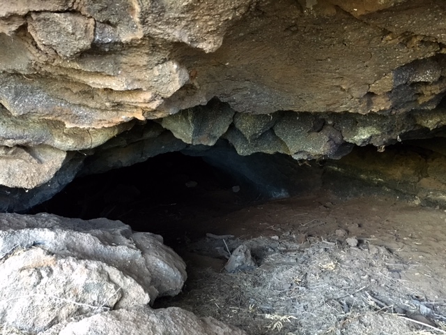
A cave about thirty-five feet above the dry wash on the cliff adjacent the ruins.

Posted in Hawaii | Tagged , , , , , , , , , , | 7 Comments

‘Akaka Falls, Hawaii & Cliff Climbing Goby

image
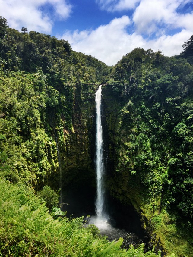
‘Akaka Falls on Kolekole Stream on the Big Island of Hawaii plunges 442 feet.

‘Akaka Falls may be one of the most remarkable waterfalls in the world. Not because of its impressive height nor natural splendor, but because of a tiny fish measuring no longer than five inches that lives in the creek, and which accomplishes an extraordinary journey as part of its life cycle.

The Hawaiian freshwater goby or Lentipes concolor was a traditional food source of the ancient islanders. It was raised in the waters of flooded taro fields in an early system of aquaponics, wherein the fish and plants were farmed in a symbiotic relationship.

Today the ‘o’opu ‘alamo’o, as it is known in the Hawaiian language, is noted for its incredible ability to scale the 442 foot sheer cliff over which ‘Akaka Falls pours to reach its natal habitat and spawning grounds.

imageA male Lentipes concolor. The fish is endemic to Hawaii.

The following description is taken from an interpretive sign near the waterfall:

“The name ‘o’opu ‘alamo’o comes from the Hilo area and refers to the lizard-like (mo’o) shape of the head.

The scientific name for the ‘o’opu ‘alamo’o is Lentipes concolor. This name recognizes the ability of the male to change colors during courtship and periods of aggression.

For the ‘o’opu ‘alamo’o, a native goby living in Kolekole Stream, life is full of challenges. Imagine having to swim 2.5 miles upstream from the ocean and then climbing 442 feet straight up against the flow of the waterfall!

An ‘o’opu begins as an egg laid in the upper reaches of the stream, often between rocks in the streambed. Once the egg hatches, the embryo drifts downstream with the current to the open ocean. Here the larvae remain for up to six months. When the ‘o’opu receives the freshwater signals from the stream, it’s time to begin the swim back upstream.

The ‘o’opu uses its suction disc and pectoral fins to climb up the water-slickened surfaces along the rocky sides of the waterfall. As an adult, the ‘o’opu measures about five inches. It stays upstream amongst the rocks and lays its eggs to start the next generation of ‘o’opu.”

image

Kirill Vinnikov, a PhD student working in the Department of Biology at the University of Hawaii whom researches amphidromous gobies, provides an explanation that helps clarify the graphic above which is posted near ‘Akaka Falls:

“All species of gobies have a unique morphological feature: their adults have a peculiar fusion of pelvic fins to form a disc with a strong sucking power. Amphidromous gobies use their sucking disc to move upstream; the disc allows them to attach to stones and climb on vertical rock surfaces, and finally, to reach their home habitats even when they are located at high elevations above waterfalls.”

Posted in Hawaii | Tagged , , , , , , , , , , | 4 Comments