Santa Barbara County Morels

Morel growing under a coast live oak tree with California poppies. (April 2025)

Related Post:

March is For Morels

Posted in Santa Barbara | Tagged , , , , , , , , , , | 3 Comments

Hollyleaf Cherries Golden Morph

Tafoni on a slab of exposed bedrock beside the golden cherry bush. It recalls the mind warp rock n’ roll nightmare of local band, Rich Kids on LSD, and the bubbles on their Reactivate album cover.

“Of all our native shrubs, there is none more beautiful than this wild cherry with its rich, deep green holly-like foliage and sprays of white flowers.”

—Theodore Payne, California Native Plants, (1941)

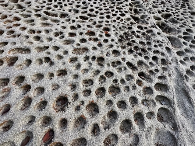
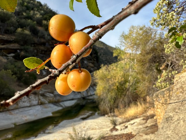
Golden cherries ripening riverside in October, 2024.

Never had I seen a holly-leaf cherry, Prunus ilicifolia, with golden fruit until we spied this bush clinging to a fractured bedrock outcrop, overlooking the Wild and Scenic Sisquoc River.

It’s not uncommon to see some cherries with patches of yellowish or golden hues as they ripen.

Most generally, however, the cherries ripen to a deep burgundy or plum color, almost black when at their best. “Red to blue-black,” as listed by the University of California Jepson Herbaria.

I regularly eat mountain cherries seasonally when walking the wildlands of Santa Barbara County.

The fruit is sweet and with good flavor profile; a rarity in the forest. If less than fully ripe they may hit the palate with a tinge of astringency.

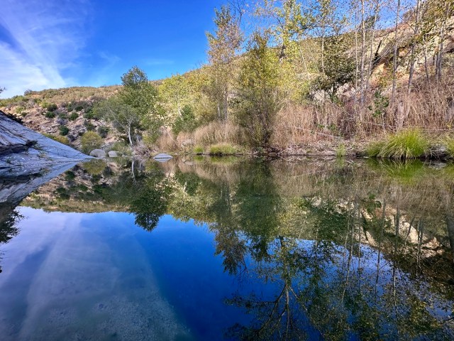
Sisquoc River serenity.

When in the way out of Condor National Forest—meant by Craig Childs as a far-off place, as in way out there, not a trail leading out—these juicy and sugary wild fruits are a big score, when all I have with me is what little I can carry, “self-contained, a kind of casual turtle carrying his house on his back.”

Although there is only a slim layer of fruit pulp to enjoy, and a massive seed stone to spit out, it’s still very much worth eating as a tasty treat.

The skin tastes pleasant, too, not like that tart bite characteristic of, for example, Burbank’s Santa Rosa plum.

And this waxen seed sheath provides the added benefit of fiber, which offers a small shot of sustained energy.

The cherries ripen in timely fashion, during the height of the forest’s hottest, driest time, in September and October.

A ten minute’s respite trailside nibbling wild cherries is rather enjoyable at this time of season, in a land of meager provisions and a dearth of sweetness and juice.

Related Post:

Holly-leaf Cherries

Sisquoc Falls: A Little Known Region In California Explored (1884)

Posted in Santa Barbara | Tagged , , , , , , , , , , | Leave a comment

Barefoot Prints In Volcanic Ash, Hawaii (1790)

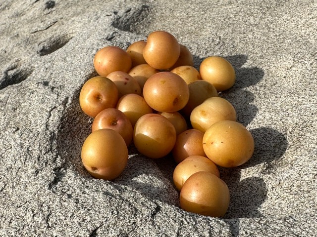
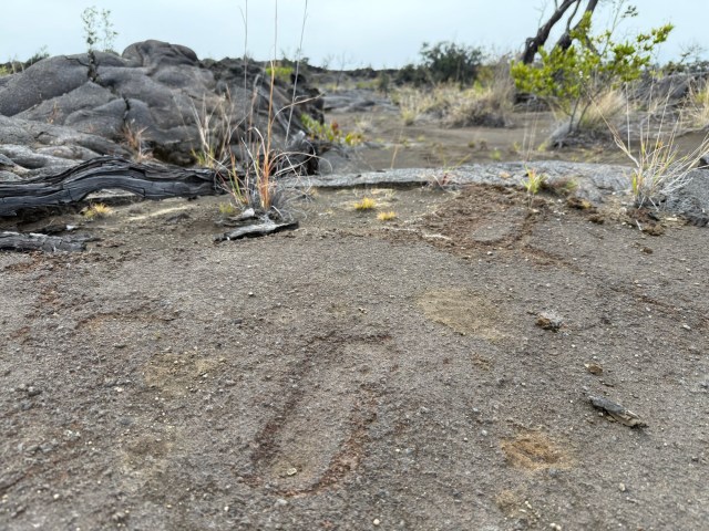
Western slope of Mauna Loa (13,100′). The old trail of footprints lies somewhere beneath the cloud cover.
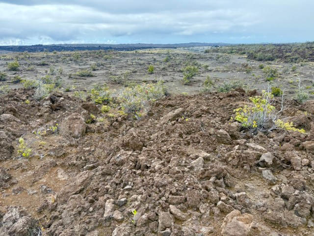
 A few months after arriving in Hawai‘i, Perkins was in the Kona area of the Big Island collecting on the western slopes on Mauna Loa, which are characteristically covered with sharp clinker lava flows called ‘a‘a. This rubble-like ground cover is not only treacherous to any confident footing, but the razor sharp edges of the ‘a‘a can do quick damage to the foot coverings of the uninitiated. It was only a matter of days before the boots Perkins wore were torn to shreds. Instead of spending more of the Committee’s scant funds to purchase more boots, he opted to go barefoot while collecting. This proved so successful, that he continued his barefoot collecting throughout most of his sojourn in the wilds of Hawaii’s forests, to the amusement and concern of his sponsors and family.

—Barefoot On Lava: The Journals and Correspondence of Naturalist R.C.L. Perkins in Hawai’i, 1892-1901

The Ka’u Desert.

Thirty minutes into the desert afoot I pull up short to survey the ragged land.

Scanning the lava field in a 180 degree fan, I observe and ponder matters of geography and hydrology.

Then I set out deeper into the sere wastes following no trail.

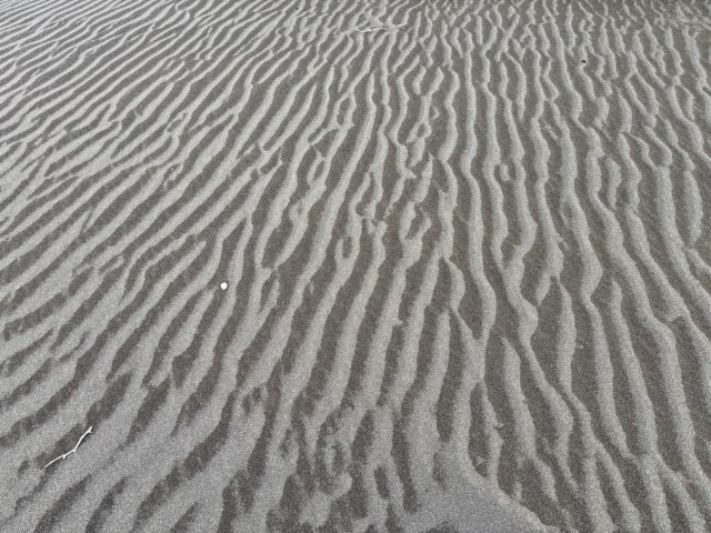
A sloping deposit of soft, deep sand, textured by wind.
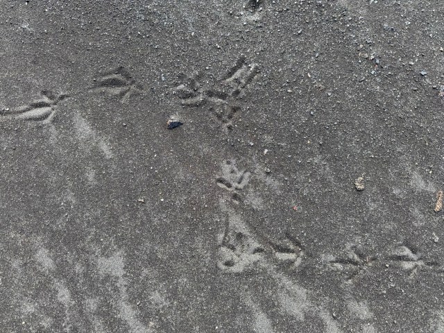
I navigate by line of sight, with no directions or coordinates to follow on a digital device.

I’m old-school analog. Reliance on electrified devices and screens dull senses and lessens experience.

I do not own a handheld computer to access the U.S. government’s Global Positioning System and I have no list of coordinates I keep on file.

Soon into the blackened desert and I’m within it, consumed by it, and concerns of getting disoriented and lost creep into my mind.

These feelings of insecurity add to the adventure and sharpen senses.

I leave only slight marks on intermittent patches of packed sand and nothing on lava stone.

To the untrained eye—myself included—it might be difficult if not impossible to retrace my steps.

In usual fashion, as is my habit wherever I walk, I avoid if possible stepping on sand or any sediment fine enough to leave a trace.

I dislike leaving footprints as much as I dislike seeing them.

If I must pass over untracked sand I do so on the periphery, along the borderline of scrub or stone and sand.

I constantly check my back trail. The way back always looks different than the way forward.

Looking back from where I came I trace my route physically with a finger held aloft, while reciting my perceived course out loud.

To see, say and scribe imprints this information onto my mental hard drive with greater accuracy and assurance that I will remember it.

Maybe.

Early morning started with blue skies and few clouds.

Yet, now with even the respite of building cloud cover I feel taxed, light headed and drained to an extent disproportionate for how little ground I have covered.

The heat and humidity in this high desert of 3,500’ is punishing.

I’m covered head to toe in thin fabric attire, thumbs through sleeve loops, hat, hood and sunglasses.

I bare only the oval of my face and half of each hand to the relentless sun.

The hotter it gets the more I wear, not less, like the Saudis, who would be caught dead if in t-shirts and shorts.

bird brain

I sip shots of tepid water from my backpack through a silicone nipple.

It’s local and natural water, recently fallen from clouds into an old-growth jungle not too far from where I am now in desert, a jungle wherein trees have been dated to 1,500 years old and giant Hawaiian tree ferns grow in stands over ten feet tall, trunks 12 to 14 inches or more in diameter.

The radical change in land comes quick and close together, jungle abutting desert.

The rainwater I drink is taken from a catchment system, carbon filtered and purified by ultra violet rays.

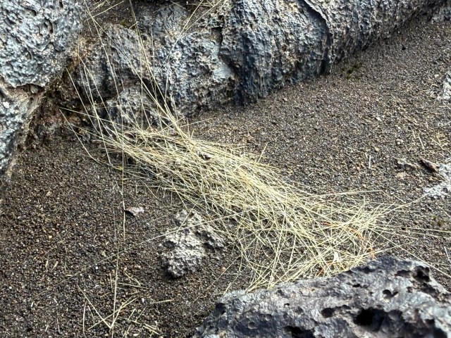
Threads of volcanic glass called Pele’s hair cover the Ka’u Desert in thin filaments and windblown windrows, looking remarkably similar to blonde human hair.

Pressing on I come to the first particular spot I feel holds real potential.

I did not know what I was looking for, but this looks like it.

The outcrop looks like hardened mud compared to its surroundings.

It’s a small panel of exposed canvas, so to speak, notably different than the surrounding ragged, smooth or rumpled lava rock and more permanent than the shifting sand.

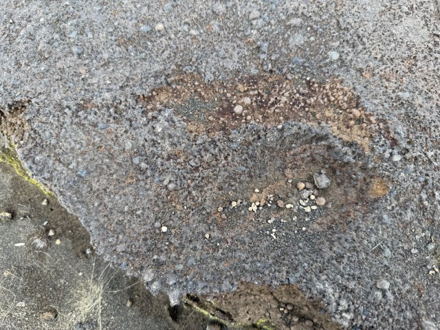
The thin layer of ashen mudstone, undercut by runoff, whereupon lie the foot prints.

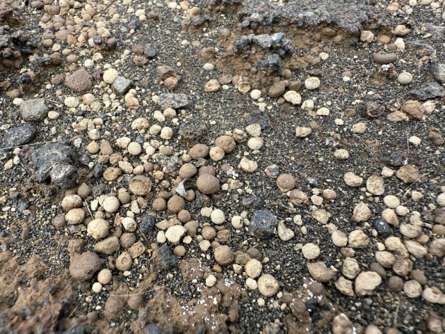
Tiny balls of mud permeate the ash deposit, as seen with a close look at the previous photo. Once liberated from the deposit by erosive forces, the bb-sized balls litter the desert floor. Did these concretions fall from the sky as muddy rain drops, caused by the thunderstorm rains of 1790?

The deposit runs only one to two inches deep, once covering the entirety of the volcano’s foot, but now only visible in busted plates.

It’s solidified mud made of volcanic ash.

The ashen mudstone lies across the land in sparse patches, here or there, not much, not large, mostly buried in sand and broken and washed away from thunderstorm runoff over the last 230 years or more.

The ash was first deposited as mud falling from the air during thunderstorms triggered by a terrific volcanic ash eruption around 1790.

The muddy ash rained over the land and the people thereon.

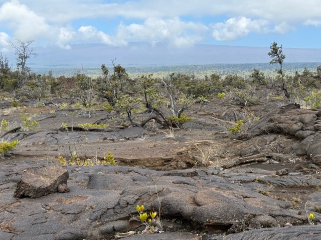
In the area under the clouds, as shown in the very first snapshot in this post, the prints cross through middle frame here, the western slope of Mauna Loa in the distance.

I see the first print! And it’s astonishing.

I look in the direction of travel. It looks like hell on earth, even more ragged and less plant life than where I stand.

A moment later I find another panel with two different trails of tracks comprised of several prints.

It appears as if two people were walking together side by side at a slight distance, although it might be that these people passed at different times.

Some tracks are small and shallow, maybe that of women or children. Others are larger and deeper and might be men’s.

This particular place and these prints were once a frequented trail of importance.

Three toe prints left, two erased by erosion. (March 2025)

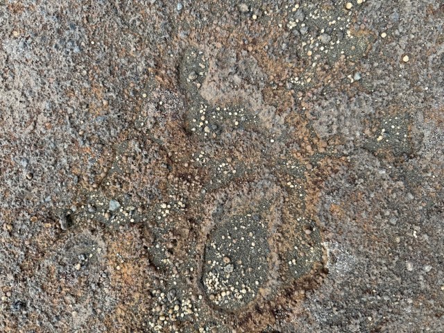
Foot held aloft, not touching the ground.

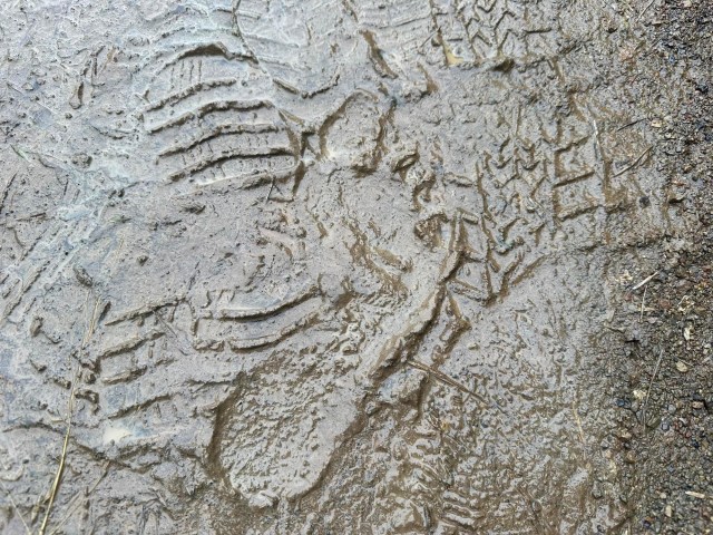
This is one of the deeper, larger footprints, showing most prominently the heel pressed into the mud, pebbles sitting in it like a bowl. The print lies at the broken off edge of a plate of mudstone, which has been undercut from runoff. The toes and ball of the footprint have been erased by erosion and washed away.

A hand for scale showing a print measuring less than nine inches long.

Further Reading:

Hawai’i Volcanoes National Park Archeological Inventory of the
Footprints National Register Site: Keonehelelei – The Falling Sands (PDF)

Posted in Santa Barbara | Tagged , , , , , , , , , , | 1 Comment

Skinny-Dipper Detained, Cuffed and Cited at Montecito Hot Springs

ADIDAS: All Day I Dream About Soaking.

“Absolutely insane. I’m blown away. Complete apathy on so many forest issues, yet this is what they decide to enforce? Bullshit.”

–Anonymous, Montecito resident of local birth

“‘If the law supposes that,’ said Mr. Bumble, squeezing his hat emphatically in both hands, ‘the law is a ass — a idiot.’”

―Charles Dickens, Oliver Twist (1837)

On February 14, I was forwarded a video from a close friend showing a man being handcuffed by two Los Padres Forest Service law enforcement officers at Montecito Hot Springs.

The video was taken by another, different person who I’m acquainted with and speak to somewhat frequently.

We believe the ham-fisted use of force over the naked recreationist, who was permitted to dress prior to getting cuffed, is clearly unmerited and for trivial matters of no honest, real concern or consequence whatsoever.

Ostensibly, the harmless skinny-dipper was detained and cited for breaking the law by moving a few small creek stones to partially rebuild a little soak pool damaged by storm runoff.

But that’s actually not really what was happening here.

Properly seen, this is the latest skirmish over public access and use of the Montecito Hot Springs in a simmering battle between average recreationists and well heeled oppositionists, between the common interest of the many and the special interest of an elite few.

Recall Brian D. Fitzgerald’s fit, the incident where a Hot Springs Lane homeowner was caught red-handed leading a demolition crew to destroy the pools:

Fitzgerald’s Fit: Man Leads Work Crew To Wreck Montecito Hot Springs

Dissecting Docherty: Eagle Demo & the Hot Springs Wrecking Crew

See also Noozhawk: Montecito’s Hot Springs at Center of Cold War Over Pools, Parking

And so the hapless stonemover’s actions appear to have provided a pretext for the oppositionists, by way of the Forest Service, to send a loud message to the recreationists at large: SCRAM!

The firearm speaks louder than the calmy folded hands. We are not fooled. This is an act of aggression. 

Context

A soaker cited for moving small stones to stack mere inches high to pool water.

At a place where we’ve seen nature pile stones and sediment over three feet high in a slug of debris 40 feet long in a single night’s rainstorm, dramatically lifting the height of the entire creek bed.

Storm runoff does nothing different than we humans do in moving rocks and altering flow, other than doing so with far more force, consequence and permanence.

The Montecito Debris Flows in 2018 killed at least 23 people and destroyed or damaged several hundred homes. Runoff flowing out of Hot Springs Canyon that morning contributed to the natural disaster. My wife knew one of the victims.

It was that natural event on the mountain that brought about the current state of existence and public use of the Montecito Hot Springs as exists today.

Humans moving stones around to form small soak pools is utterly inconsequential by comparison, no matter how you measure it.

The pools are impermanent, insignificant, benign. They’re shallow and modest in depth and size and respectful of place and setting.

We don’t believe the pools alter the flow of water in ways that cause any measurable harm whatsoever.

All the water flows downstream at the same rate in the same general manner and course as happens without the pools.

Does it make sense to dispatch law enforcement and cite people?

The use of force by the Forest Service in our local woods appears intended to squelch public recreation.

That’s a mighty peculiar strain of public service.

Pipe carrying hot springs water to select private interests holding rights. Let them have their fair share of water undisturbed. Let the people have their fair share of water undisturbed.


An Attack

The day the citing happened the creek had been tossed and turned over by runoff from recent rains.

It appears the arrival of Los Padres law enforcement officers was preplanned and consciously timed. This looks like a calculated hit.

Did the Forest Service go in expecting people (of goodwill and decent intentions) to be diverting water (repairing the pools after a rain), so the dissident transgressors (harmless folks) could be made to face justice (railroaded)?

For minor “illegal” maintenance of legal pools?

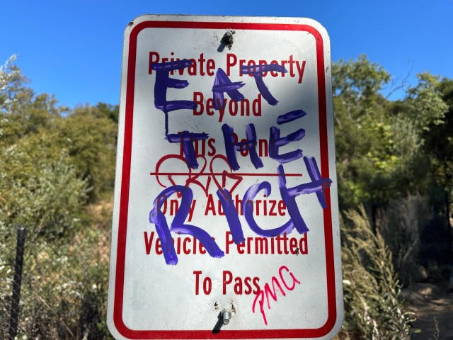
Hot Springs Trail tramps.

Making violators of well-meaning folks seeking good clean fun in pursuit of happiness.

How does this serve public interests or the general welfare?

An armed raid carried out under the guise of protecting a California waterway.

The law in this instance was employed as a blunt tool, if not wielded as a weapon like a cudgel, to accomplish the ulterior motives of the oppositionists trying to smash recreational use.

A show of brutish force to make a loud statement.

This was meant to inject a chilling effect into the hot springs scene and scare and intimidate common folk.

Why isn’t Brian D. Fitzgerald made to remove the sign he bolted to a creek boulder, which is inaccurate and misleading and misplaced?

Doublespeak

“The Montecito hot springs have been used by the public as well as the native inhabitants in this area since long before Los Padres National Forest came into being.”

“Our position continues to be that we are not removing the bathing pools, as that would amount to eliminating an established and appropriate recreational use. That said, we are also not approving building more pools there.”

–Andrew Madsen, Forest Service spokesman, as quoted in Noozhawk

Macfadyen of Noozhawk said of Andrew “Milquetoast” Madsen’s mealy-mouthed statement:

“In one of the most adroitly lame statements I’ve read in a while, Los Padres National Forest spokesman Andrew Madsen gave a master class in avoiding responsibility.”

Follow the logic and be amused over the incoherence of Madsen’s policy statements and Forest Service actions.

If the Forest Service forcibly prevents maintenance rebuilds of existing pools already deemed to be established and used appropriately, then in practice the end result of their policy amounts to the elimination of the pools.

It’s the same as if the Forest Service purposefully destroyed the pools along with Fitzgerald; the pools ruined, just accomplished by different means, nature.

It’s a theoretical distinction without a practical difference in the end. It’s a dishonest, passive aggressive policy of purposeful ruination.

What an insult. Do Andrew Madsen and Daryl Hodges think we’re thoughtless idiots? They treat us like fools.

Funny how Madsen pretends to speak so fondly of the historical and long standing use of the hot springs as a justification for their continued existence, even slipping a reference to Indians in there.

Very lame, indeed.

Now it appears clear that the unstated policy of the Forest Service is for the hot springs to be washed out and destroyed by natural forces.

The “established and appropriate recreational use,” “since long before Los Padres National Forest came into being,” is promptly ignored when not serviceable by the federal government, as if it suddenly means nothing at all, whatsoever. 

We are expected to forget it, Madsen? Take a hike.

Record of Wanton Destruction and Forest Closure

Local press wrote a puff piece introducing Santa Barbara District bossman, Daryl “Scare All” Hodges, as he is affectionately now known in this neck of the woods.

They told us romantically how he grew up “running wild up and down the creeks.”

Now Hodges serves to pester folks for soaking peaceably in creeks. He’s come a long way, indeed.

Let it be known, the Forest Service in this instance was used to thwart public use of one of the greatest public resources and founts of health and well-being on public lands in Santa Barbara County. A place with a history of human use thought to stretch back in time so far it can’t even be known for sure.

How about that?

A travesty of public service.

Will the Forest Service and Daryl Hodges be the death of this prehistoric peoples’ treasure? Will they steal our gem from us through strong-arm tactics?

It is not an unfair question. The Forest Service already has such a track record of state-sponsored vandalism toward natural hot springs and the people’s property.

They are known already as miracle killers.

Related Post:

Hiking Is Not A Crime: Done Dirty By Diktat

Posted in Santa Barbara | Tagged , , , , , , , , , , | 1 Comment

Red Horny Toad

Out for a walk with Larrold. An unremarkable lesser ridge among the rumpled hills. Chapparal, pine, gravel and grit.

Then a flash of tiny red life running cumbersome from the fringe of the trail. Startling in its ochre hue and firing a frantic scramble to capture the specimen amid a tangle of woody mountain weeds.

Fortunately, the little bugger resorted to playing dead for defense and made the apprehension possible.

Sometimes, when this small, horny toads easily get lost in the duff and are unfindable despite their relatively big, wide-gauged bodies. They also hide buried in sand.

Photo imagery doesn’t quite convey how striking the coloration appeared in the field when seen for the very first time.

The lizard would blend in better out in the purply-reddish sandstone of the Sespe Formation of Ventura County, but it was seen in the Santa Ynez Mountains behind Santa Barbara, where the sandstone is predominantly golden, which happens to match the common coloration of most local horny toads.

I have never seen a red horned toad before, ever, or even heard tell of one being seen around these parts. I wonder how uncommon, if not rare, such a red morph might be.

Decades into our Santa Barbara adventure and we’re still seeing new things out there for the first time.

The search continues.

Related Posts: 

Horny Toad

Finding Frontier In the Forest Conquered

Searching For Soul Outside the Cage

Posted in Santa Barbara | Tagged , , , , , , , , , , | 1 Comment