Matías Reyes, Santa Barbara Mission (1887)

Don Diego Guiterrez Santa Barbara Mission 1887.

“Old Matías Reyes lived in Mission Cañon. He used to bring wood to town and sell it.”

—Santa Barbara: Tierra Adorada, A Community History (1930)

In her book, “Canyon Voices: The Nature of Rattlesnake Canyon (2006),” Santa Barbara resident Karen Telleen-Lawton writes of local historian, Jim Blakley:

“Blakley uncovers a sheath of fragile, yellowed paper wrapped in heavy parchment. One document dated 1875 shows the transfer of title of much of the land in Rattlesnake Canyon to Matías Reyes. Reyes’ wife Griselda, an American Indian from a tribe near Riverside, California, signed the title with an “X.” The Reyes homestead encompassed the lower part of the canyon, including some relatively flat areas above the immediate flood channel that could provide building sites.”

Telleen-Lawton also writes of Frank Van Schaick who had lived in Santa Barbara since 1936. He was a teacher of natural history, among many other subjects, wrote the column “Nature Walks” for the Santa Barbara News-Press, and co-authored a couple of books with Dick Smith, after whom the Dick Smith Wilderness was named. Van Schaick had built with his own hands a home in Rattlesnake Canyon made of redwood and sandstone. Rattlesnake Creek is a tributary of Mission Creek. Regarding his home Telleen-Lawton continues:

“Van Schaick shifts focus and strides purposefully to the front door. He gestures to the sandstone slab doorsill, noting it came from the original adobe dwelling on the 19th century Spanish land grant of which this was a part. The Spaniard’s name, he says, was Matías Reyes.”

A seldom used and unkempt backcountry campsite located a short walk from the Santa Ynez River, beside a sunny patch of grass on the north slope of the Santa Ynez Mountains, takes its name from Mr. Reyes: Matías Potrero Camp. Reyes had staked a claim and built a cabin there, according to Blakley.

I imagine during Reyes’ time walking down to fish the river for three foot-long steelhead. (Native Steelhead of Yore, Santa Ynez RiverSteelhead Fishing, Santa Ynez River [1948])

Bald eagles and osprey would have been working the stream for fish and perhaps an increasingly rare grizzly bear or wandering wolf, both heading toward extinction. When in 1887 Jacinto Damien Reyes (no relation to Matías) arrived in Ventura County not too far away he said the forest “was infested with wolves, coyotes and grizzly bears.” (Gladiator Games of Bulls and Bears: Recollections of Jacinto Damien Reyes [1880])

Today the fish eagles still fly and we’re left with coyotes, but only a meager steelhead population of about one to two percent of its former size. “One of the penalties of an ecological education is that one lives alone in a world of wounds,” wrote Aldo Leopold. “Nostalgia for the good old days when everything was abundant is almost universal among conservationists.” Sorry for the sorrowful digression, but we can’t rightly dream of what the world can be if we don’t keep in mind what it once was.

Aside from the natural splendor surrounding Matías Potrero Camp, an old weathered handcrafted sign placed in an oak tree by Boy Scouts is perhaps the most notable human-made feature of the campsite nowadays, where the old rotten picnic bench has finally collapsed and a small stone fire circle lies rarely used.

Matias Potrero Los Padres National Forest hikes camping Matías Potrero

(Author’s note: Several sources identify the man in the historic photo featured here as being Matías Reyes. Among those sources are two mentioned here: The book, “Santa Barbara: Tierra Adorada, A Community History”, as well as historian Jim Blakley. However, it should be noted that the man is said to be Don Diego Guiterrez by somebody associated with the Black Gold Cooperative Library System and University of California.)

Posted in Santa Barbara | Tagged , , , , , , , , , | 4 Comments

Mastodon & Mammoth Sign: Reading Trees in the Santa Ynez Mountains

Santa Ynez Mountains Los Padres Forest hikes Santa BarbaraSanta Ynez Mountains

“Elephants’ habit of snapping or uprooting trees could explain why species such as oak, ash, beech, lime, sycamore, field maple, sweet chestnut, hazel, alder and willow can regrow from the point at which the stem is broken. In eastern and southern Africa there are dozens of tree species which resprout—or coppice—from the snapped trunk, and ecologists recognize this as an evolutionary response to attacks by elephants. … Trees that survive the attention of elephants often come to dominate the places in which the animals live: the ability to coppice confers powerful selective advantages.”

George Monbiot, “Feral: Rewilding the Land, the Sea, and Human Life” (2014)

I went for a walk in the woods up an unnamed trailless canyon in the Santa Ynez Mountains. That water trickled in the creek was probably sign enough somebody was growing weed somewhere nearby. Marijuana seems to be everywhere that there is water in the forest.

Sure enough I came across an old grow site. The guerrilla growers had thinned the forest canopy and understory to let sunlight onto the ground where they had rooted their crop. I could make out vague depressions in the earth that had once held the pot plants, now filled with leaf mulch and the flush of annual spring greens.

caost live oak tree coppiceA coast live oak tree (Quercus agrifolia) cut in half by the growers that resprouted a limb.

A number of oak trees had been cut in half or coppiced some time ago by the growers, but had resprouted from the remaining trunks. How hardy are the oaks.

Fell an oak near ground level and a burst of new branches explodes from the stump. The burly hardwood withstands much abuse in campsites and other popular areas: shot for target practice, chipped and hacked up with hatchets and axes, and used as billboards for the carving of initials, driving of nails and stakes and whatever else. The scars can last decades.

Sometimes one finds old barbed wire fencing strung through the solid live wood of big trees. One can still see today in the backcountry of Santa Barbara County an “E” and an “F” carved into an oak around a century ago by the son of a pioneer family. (Eddy Fields’ Initials)

In A Sand County Almanac (1949) famed conservationist Aldo Leopold wrote of reading pine trees like books on his Wisconsin farm. The “spaces between the successive whorls of branches … are an autobiography that he who walks with trees may read at will.” The longer the space between each annual whorl of branches, Leopold advised, the more rain had fallen the previous year. The shortest spaces reflect drier years and droughts.

I wondered if, to the keen observer 100 years hence, the signs of marijuana grow sites would remain evident in the particular form of the once butchered trees, which had sprouted new limbs and grew on.

coast live oka treeAnother tree that was decapitated by the growers and sprouted new branches.

But what else might the observer glean about the past from the way the trees appear today? What else might one read in the subtle clues of the forest? The “small-talk,” as Leopold called it.

In the particular growth habit of the oak had I also been witnessing a telltale sign of the late proboscideans, the distant relatives of today’s elephants that once thrived in California?

Was it a defensive characteristic imprinted through evolution into the tree’s genetic code in response to the behavior of American mastodons or Columbian mammoths, which had grazed or mauled the trees for so long?

Coast live oaks dominate the landscape around these parts like few if any other trees. One wonders if this is in some part due to the elephant-like megafauna that roamed the region during the Pleistocene and evolved alongside the trees. Prehistoric herbivores whose behavior was perhaps similar to that of today’s elephants, and in turn whose evolutionary influence might account for the particular growth habits and adaptations of certain trees, as Monbiot suggests.

santa barbara pygmy mammothA fossil pygmy mammoth (Mammuthus exilis) skeleton found in Santa Barbara County, as displayed at the Museum of Natural History.

santa barbara mammoth mastodon natural history museumA painting at the museum depicting a Columbian mammoth and the smaller American mastodon.

Posted in Santa Barbara | Tagged , , , , , , , , , | 4 Comments

Arlington, Cathedral, La Cumbre Peaks Scramble & More

Santa Barbara hikes Arlington Cathedral La Cumbre PeakThe stairway to Arlington climbing out of Mission Canyon.

“Genji climbed the hill behind the temple and looked off toward the city. The forests receded into a spring haze.

‘Like a painting,’ he said. ‘People who live in such a place can hardly want to be anywhere else.'”

—Murasaki Shikibu, “The Tale of Genji” (1008)

A smattering of rain has moistened the Santa Ynez Mountains raising the seasonal precipitation total to 72 percent of normal county-wide, better than each of the four previous seasons, but not what was expected this year during the strongest El Nino ever recorded. The weather is cool. A low ceiling of shifting cloud cover obscures the peaks over town sprinkling them in intermittent showers of light rain.

Be back by four, she says. That allows six hours, which isn’t enough time, but I go anyways. I have to go. “The mountains are calling and I must go,” John Muir wrote. I’ve never heard that call, but I think I’ve felt it.

Drop by seldom seen drop on through another warm and dry winter in this fifth year of epic drought. Any moisture falling from the sky provides an irresistible impetus to get out for a walk in conditions that are fleeting and seem to be increasingly uncommon.

I keep thinking I need to read Edward Abbey again to get used to the coming desert.

Arlinton Peak hike Santa BarbaraAnother look up the stairway to Arlington. The trail winds through the rocks to summit in the clouds.

Arlinton Peak hike trail santa barbaraThe trail passes under this jumble of boulders shown here and below.

Arlinton Peak trail hike Santa Barbara

On spotless days exceptional long views from the eastern salient of Arlington Peak; look over the canyons to the Santa Barbara littoral and the Pacific Ocean and Channel Islands beyond. What about the messy days? With low clouds and rain the hike takes on a mysterious and intriguing quality.

On cloudless days land lays bare under glaring sun; the nude sunbather on the beach leaving nothing to the imagination. The curves of the mountain, the hills, ridges, valleys and peaks are seen for what they are. It’s all out in the open.

Secreted away in clouds and only partly seen, however, an eager imagination will paint fantastic landscapes, completing the rest of the unseen picture in the mind and making the peaks rise another few thousand feet. A brief flash of a thought and it’s gone. The intrigued mind takes over as the mental image fades. Who knows what could be up there hidden amid the swirling mist of the coastal cloud forest? What country am I in? The mind wanders, enamored with the possibilities.

The airborne droplets flow over the sandstone and chaparral of the mountain slopes, thickening and thinning, enveloping and reducing vision to a matter of feet, the rocky hillside fading into the grayness, then release from the cool darkened grip gives way to views thousands of feet below.

I march on along a trail I’ve walked before, but through an enchanted cloudland I’ve never seen, a hunched character in the hazy montane landscape of a Japanese sansui painting. I perch on a boulder gazing into the distance over the city as a red-tailed hawk floats by at eye level screaming at me. The mind wanders, enamored with the possibilities.

Cathedral Peak hike Santa BarbaraApproaching Cathedral Peak along the saddle from Arlington.

Cathedral Peak cave hike Santa Barbara La CumbreLooking out of Cathedral Peak cave over Santa Barbara and the Pacific Ocean.

La Cumbre Peak Cathedral Peak trail hikeThe trail cutting through a patch of miner’s lettuce along the saddle between Cathedral and La Cumbre peaks.

La Cumbre Peak hike Santa Barbara Los PadresView from La Cumbre Peak of the backsides of Cathedral and Arlington.

La Cumbre Peak Fire Lookout Santa Ynez Mountains Santa BarbaraLa Cumbre Peak fire lookout.

Arlington Peak, Cathedral Peak cave La Cumbre hike santa barbaraThe banner feature photo for the blog shows the peaks in question lined up; the pyramidal Arlington just right of center frame, the huge sandstone knob of Cathedral, and the conifer-capped mound of La Cumbre on the top left.

After a couple of hours of sipping warm Santa Barbara tap wateran acquired tastethe shady and cool low saddle between Cathedral and La Cumbre provides an abundance of crisp and succulent miner’s lettuce beaded with rainwater. I kneel down and snatch it up by the handful, eagerly chomping it down and enjoying the tasty refreshment before the slog up the steep south face of La Cumbre.

Rain begins falling somewhere along the three mile stretch of Camino Cielo Road on my way from La Cumbre to Arroyo Burro Trail. I had walked from Tunnel Trailhead up to Arlington summit, to Cathedral cave and on up to La Cumbre. It’s a steep and sassy two and a half miles up.

My feet and legs like the flat asphalt road and push the pace leaving the battered old fire lookout atop La Cumbre behind without stopping to rest. But my mind does not settle until reaching Arroyo Burro. Back on the dirt; into the bowling upper canyon of San Antonio Creek; the rain pattering against me. You know the smell of wetted woods and fields of grass; the soft and subtle sounds of damp forested mountains, a trickling creek.

prickly phlox santa barbara wildflowersLeptodactylon californicum (prickly phlox)

Anise swallowtail caterpillar santa barbaraAnise swallowtail caterpillar.

Santa Barbara hikes Arroyo Burro Trail Santa Ynez Mountains Los PadresArroyo Burro Trail runs out of the lower right-hand corner of the frame as it drops into the canyon shown below.

Arroyo Burro Trail Santa Barbara hikes Santa Ynez Mountains

Arroyo BUrro Trail hikeUpper Arroyo Burro Trail.

Arroyo Burro Trail San Antonio Creeks Santa BarbaraSan Antonio Creek crossing.

phacelia santa barbara wildflowerPhacelia grandiflora

Santa Barbara newtA California newt (Taricha torosa) crossing the trail heading away from the creek.

rattlesnake hike santa barbaraSee the viper. 

Five hours into the walk and I’m on autopilot stomping along Arroyo Burro in the rain, traversing eastward below Barger Peak after having climbed out of San Antonio Creek. I’m energetic, my body eager to walk, my mind happy to endure. I feel like I have “the body of a taught, preteen Swedish boy.” I want to complete the 14 mile loop, merging onto Jesusita Trail and back up to Tunnel Trailhead where I parked, but I’m out of time, supposed to be home. That’s what she said.

Then I see the rattler. A juvenile coiled in the middle of the trail. On a cool and rainy day in late afternoon it’s among the last things I expect to see.

Fortunately it’s wound up in a circular shape that stands out from its surroundings and I spot it and it registers accurately in the brain. Had it been stretched out my eyes might have seen it, but my mind might have passed it off as just another twig on the trail. Who expects a snake in the rain on a cool afternoon? Its fangs would have readily pierced my thin and worn nylon pants; a wee spot o’ wild in the wilderness. I stop. Admire. And plod on.

The trail becomes overgrown with scrub and grass, hard to impossible to see clearly. After the viper it’s not a comforting occurrence. Were I to slow enough to make certain I see the trail and avoid stepping on a snake it would take me four times as long to finish the hike. I stomp on without regard or slowing my pace, plowing through the drenched brush getting showered in water and playing the odds, hoping they’re in my favor, that I won’t get bit.

rattlensake

rattlesnake santa barbara hikingI opt out of the hike prematurely, leaving Arroyo Burro and walking down lower Jesusita to Steven’s Park, where I get a ride home just a few minutes away. I suppose the distance for the day at 11 miles.

Next go around I’ll have to allow enough time to complete the loop; the Santa Barbara Triple Crown. Start at Steven’s Park, up Jesusita to Mission Canyon, up to Arlington Peak, Cathedral Peak, La Cumbre Peak, across Camino Cielo, and down Arroyo Burro to Jesusita and back to Steven’s.

It’s nowhere near as long or grueling as my friend Stillman’s 28 mile “masochistic odyssey” that he dubbed the Ojai Triple Crown, but it’s a worthy hike nonetheless. I’d rate it, myself, as the best hike in the Santa Barbara frontcountry.

Arroyo Burro Trail hike Santa BarbaraView from Arroyo Burro Trail looking up San Roque Canyon at the three peaks from whence I came.

Posted in Santa Barbara | Tagged , , , , , , , , , | 10 Comments

Sage Hill Wildflowers

Grass Mountain Figueroa wildflower poppy lupine bloomCalifornia poppies on Grass Mountain, Zaca Ridge, Figueroa Mountain 3-26-2016

Around these here parts, in a mild climate with little to no snow, the wildflower blooms mark one of the few striking signals of seasonal change. The go-to sites in Santa Barbara County might be those on Figueroa Mountain. What might be called Figueroa Prime, a poppy and lupine field located roadside at the junction of Figueroa Mountain Road and Catway Road, is usually worth a look and typically attracts a weekend stream of “industrial tourists.”

The face of Grass Mountain lures in a veritable stampede during a good year with cars overflowing the parking lot at the trailhead and lining both sides of the road for some distance. When in full bloom the pyramid-shaped grassy face of the mountain can be seen from well over twenty miles away, from along the crest of the Santa Ynez Mountains above Santa Barbara.

In early spring, from the top of San Marcos Pass, it’s easy to tell if the poppies have opened before making the hour long drive back to Figueroa for a tour. When Grass Mountain can be seen lit up orange, twenty miles yonder as the condor flies far across the Santa Ynez Valley, then it’s on.

Sage Hill wildflowers Santa Ynez Los PadresKite flying below Sage Hill with a glimpse of the poppy fields abloom thereon.

One of the better bloom sites this season, however, came at a quieter and lesser visited nook of the Los Padres National Forest that’s not typically known for flowers. On Sage Hill along the Santa Ynez River the wildflowers showed with an intensity rivaling Figueroa. The area burned about three years ago in the White Fire, as seen in some of the photos with the blackened skeletons of sagebrush still standing.

The bowl-like canyon on the south slope of Sage Hill bloomed big. In some patches the flowers seemed to lay petal to petal across the slope in huge wind rippled blankets of solid color. While some of the flowers on the hill were visible from the river below and from afar along San Marcos Pass, the small canyon where it bloomed best was largely out of sight tucked behind the folds of the grassy mountain, fully revealed to only the few people curious enough to wander without trail up the steep hillside.

It was not until I crested the summit of Sage Hill and began walking down the steep south face that the full extent of the flower field came into view far below. It was good to epic. The subtle, sweet fragrance of thousands of flowers wafted far and wide across the mountainside in the afternoon breeze. Carried in the wind down the slope, I could still smell the fields of flowers when walking along the riverside grassy flat at the foot of Sage Hill far below and away from any of the blooms.

poppy lupine santa ynez wildflower 2016

poppy lupine santa ynez wildflower bloom 2016

poppy lupine wildflower Santa Ynez Mountains

poppy lupine wildflower bloom Santa Ynez Los Padressanta barbara los padres wildflower 2016 figueroabuzzard wildflowers

santa barbara wildflower 2016 los padres santa ynez Figueroa

santa barbara wildflowers los padres hikes

poppy lupine santa barbara wildflowers

poppy lupine wildflower bloom 2016 santa barbara
white lined sphinx moth caterpillarA white-lined sphinx moth caterpillar.

Hundreds of sphinx moth caterpillars were crawling all over the mountainside munching the wildflowers. A week ago Pascal Baudar a wild food instructor and author of the brand new book, “The New Wildcrafted Cuisine: Exploring the Exotic Gastronomy of Local Terroir” featured these worms in a post on his Facebook page. He described them as an “amazing and actually delicious food” with a “nutty” flavor. See his cooked worm photos and full comment at this link.

Sage Hill Los Padres Santa Ynez River Santa Barbara hikeLooking down slope at the foot of Sage Hill and toward the Santa Ynez River just out of frame.

Related Posts:

Birabent Canyon and Grass MountainGrass Mountain Figueroa Midway hikes los padres

Grass Mountain and Zaca Peak

Figueroa Wildflowers 2010

Posted in Santa Barbara | Tagged , , , , , , , , , , | 6 Comments

Sitiptip Flat, Los Padres National Forest

Salt Seep Flat Los Padres National Forest
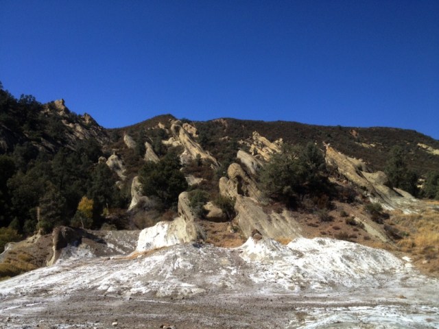
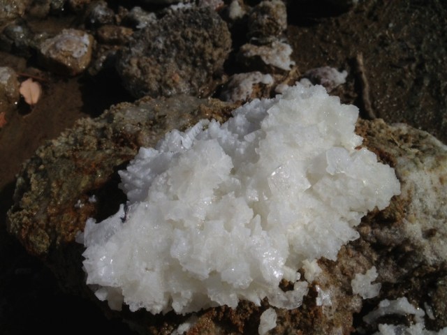
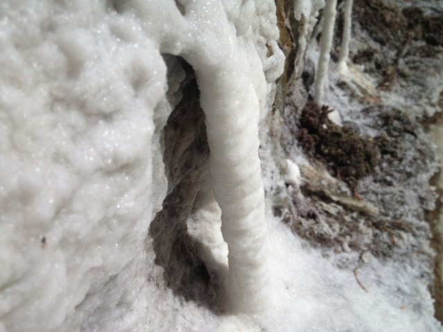
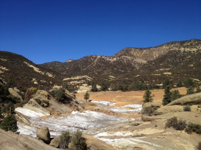
The place. Note the white mineral deposit on its far side.

“Our history is carried by word of mouth, but it’s anchored to the land. The old boys used to play a game: one of them would leave his cap on a rock, somewhere in the mountains. Then he’d go into the pub and tell the name of the rock to a friend. That was all the information they needed. The friend had to run out and retrieve it. All the rocks had names. My uncle could remember all of them. They were never written down.”

Dafydd Morris-Jones, as quoted by George Monbiot in “Feral: Rewilding the Land, the Sea, and Human Life” (2014)

So far as I know, which isn’t much, this here field is officially unnamed. How has it escaped this long? Isn’t everything labeled these days? It seems like a remarkable enough place that it would have a name by now.

Among the Chumash, the Spaniards and Californios and early Americans that followed, surely the place had a name. Through the years, the millennia, at some time it must of had a name.

Salt Seep Flat

“It’s landscape associative. Folk traditions and oral history always have been. Professional history tends to regard a fascination with place as antiquarian. But mythology is all about place. . . . I wish the West Texas pioneers, like those in the Far West, the Deep South, even New England, had learned and retained more of the Native American names once attached to these canyons.”

Dan Flores, “Caprock Canyonlands: Journeys into the Heart of the Southern Plains,” (1990)

As with the Comanche and Kiowa of which Flores writes, sense of place and the importance of the landscape figured prominently in Chumash culture. Whereas in American culture places are often named after people, the Chumash tended to name people after places. Each prominent geographical feature likely had a name and placenames were commonly taken from minerals found in the area. Applegate quotes Harrington: “In ancient times there must have been placenames all up and down the canyons.”

A place of this remarkable nature a grassy flat with a mineral deposit, near a river once stuffed with steelhead trout, at the foot of pine capped mountains once teeming with game  seems like it would have been an attractive location in times past. It’s just a wild guess.

Salt Seep Flat Los Padres hikes

When I hiked through in 2011 I don’t recall the area being as salty as it was this last summer. Maybe because back during that particular season a lot of rain had fallen, 160 percent of normal county-wide up in Santa Barbara, and the minerals were diluted by abundant freshwater.

After several years of drought the crusty white buildup was much more extensive in late 2015, as shown in the snapshots. In some places the crystals were finely shaped and well-developed. Small puddles of extremely concentrated salt water pooled in the cavities of the rock that when stirred with a stick swirled like oil in water.

Salt crystal Los Padres Forest hike

The word for salt in Barbareno Chumash is tip. Adding emphasis through reduplication signifies that there is a lot not just a little. Thus tiptip may be roughly translated as “lots of salt.”

“Goleta Slough was called tiptip, ‘salina, salt flat,’ and not surprisingly, the Ventureno equivalent sitiptip was applied to Hueneme lagoon,” Applegate writes.

Alternatively, sitiptip might be understood to mean “the place with lots of salt.”

Salt Seep Flat Los Padres Sespe hikesSalt Seep Flat Sespe hikes

Posted in Ventura | Tagged , , , , , , , , , , | 12 Comments