Wisdom for the Wilds from Louis L’Amour

On being observant and habitually taking visual note of your surroundings from differing angles when in the wilderness:

“Busy as I was now a-talking, I found time to check my back trail. A man who travels wild country gets to studying where he’s coming from, because some day he might have to go back, and a trail looks a lot different when you ride over it in the opposite direction.

Every tree, every mountain, has its own particular look, and each one has several appearances, so you look back over your shoulder if you want to know country.”

Louis L’Amour, Mojave Crossing

Consider the experience of a local California hiker named Fred Heiser:

“I retrieved my ball of clothes and carefully worked my way back downstream and almost missed my gear again. The place I hid them [sic] didn’t look at all like it did when I’d first come down and I had hidden it very well indeed. Somehow the shifting shadows and reduced light made everything look different. But I knew it HAD to be there so I persevered and found them.”

Tar Creek Adventure September 18, 2003

Or the far more disastrous experience of Raffi Kodikian, which culminated in the killing of his friend after getting lost in the Chihuahuan Desert in 2000:

Kodikian’s Defense Attorney in court: “Did you ever stop at the top [of the canyon on the trail] and take a good look all the way around you to orient yourself as to where you were?”

Kodikian testifying on the stand: “We looked at the canyon on the way in. We were looking at what was in front of us. I’d say our first mistake–in hindsight–our first big mistake as far as getting lost went was when we got to the bottom of the entrance trail we didn’t turn around and look back at what we had just come down out of. We were looking ahead. We stopped for a couple of minutes and had some water, but we didn’t really look around to check out our surroundings.”

Jason Kersten, Journal of the Dead: A Story of Friendship and Murder in the New Mexico Desert

Posted in Louis L'Amour | Tagged , , , | Leave a comment

Potrero John Camp (Sespe Wilderness)

Potrero John Camp

1.7 miles from Potrero John Trailhead to Potrero John Camp in the Sespe Wilderness

Trailhead located on HWY-33 at Potrero John Creek

Elevation: Trailhead 3696 Camp 4152

The trail leaves HWY-33 plunging instantly into the spectacular gorge cut through the rugged and rocky pine studded terrain by Potrero John Creek. On the other side of the gorge, it opens up into a fairly wide open wash-type expanse created by the torrential runoff that drains into Potrero John Creek from the Pine Mountain watershed, which is formed by Reyes Peak (7514) to the west and Haddock Mountain (7361) to the east. Potrero John Camp is set beside the creek beneath these mountains.

The camp makes an excellent staging ground for further exploration of Potrero John Creek. Up the canyon 1.2 miles from camp is Potrero John Falls. Several other smaller falls are located along the feeder streams that drain into the creek from Reyes Peak.

Potrero John Creek watershed can be extremely dangerous during rainy weather due to flash flooding and mud and rock slides: Rescued Hikers on Potrero John January 18, 2010

Trail cutting through the rocky gorge at dusk.

Deadfall washed off the mountain lies as silent testimony reflecting the level and force of runoff flushing down the canyon in winter.

A fairly large cottonwood tree snapped like a toothpick.

Trail leading out of the gorge in fall with red-tinged poison oak.

Potrero John Camp beneath the peaks.

Potrero John Camp is located under the oaks beside the creek.

The camp in October with water still flowing in the creek.


Posted in Backcountry | Tagged , , , , , | Leave a comment

Dragon’s Back Ridge on the San Andreas Fault, Carrizo Plain National Monument

Dragon’s Back Ridge is the result of the tremendous pressure along the San Andreas Fault that runs through the Carrizo Plain National Monument. The ridge is located southeast of the Wallace Creek offset and contains its own offset drainage channels. It can be accessed from Elkhorn Road.

Click for full screen view of Dragon's Back.

Click for full screen.

On the Carrizo Plain, in the shadow of the Caliente Range, overlooking spring flowers with Dragon's Back Ridge in the background.

A more detailed write up about Dragon’s Back Ridge and the San Andreas Fault, along with aerial photos, can be found at the following link: Ramon’s Image Gallery

Posted in San Luis Obispo | Tagged , , , , , , | Leave a comment

Pine Mountain Fossil Foray

Prime fossil hunting grounds at the foot of Pine Mountain, Ventura County.

With the tail end of a thunder storm swirling its way down the coast and through the area, I checked the online weather radar and saw that only a few scattered showers remained. The mountains looked surprisingly clear of rain. So I gathered my gear, loaded it up and hit the road for Pine Mountain.

The showers started on the drive up HWY-33 behind Ojai. Sitting in my truck roadside a few minutes later as I pulled on my waterproof gear, the showers continued intermittently, but as I started up a creek, the rain stopped. Thirty minutes later I was sitting in a dry shelter beneath a massive wall of sandstone hiding from the sheets of rain pouring down from a grey-black sky. Figuring I had five hours of daylight left and hoping that the clouds would soon clear, I kindled a small fire, took out my thermos and Louis L’Amour novel and sat back to read and sip coffee.

The rain ceased, the clouds parted to blue sky and the sun came out. I headed up a fork in the creek with the fragrance of rain soaked forest heavy in the air and the hills echoing with singing birds. It was not long, however, before I noticed the clouds gathering once more on the summit of Pine Mountain, which soon disappeared in a grey shroud of falling rain. A flash of lightning, a few heavy rain drops and then it cut loose so fast that I still had my slicker in my backpack. The thunder boomed, cracking through the sky overhead. Hastily fumbling in the downpour trying to don my jacket, I ripped the hood from the buttons by accident and had to reattach it wasting precious seconds and getting soaked.

Fossilized sand dollar.

I started back down the creek slipping in the mud as torrents of chocolate milk-colored rivulets came streaming down the hillsides rapidly filling all the gullies that had been dry minutes earlier. Lightning bolts flashed down followed by thunder claps that I could feel resonating inside me. Then it started to hail.

That is when I spotted a fairly nicely preserved fossilized sand dollar and knelt down to pick it up as little balls of ice slammed down all around me in the mud. The weather added an enjoyable element to the experience. The mountains were alive. There I was hunched over in a hail storm scanning the ground for fossils with thunder and lightning flashing and crashing all about.

I quickly looked around the immediate area and seeing nothing of interest headed down canyon through the downpour growing a bit concerned about flash flooding. Oddly, though, I reached the end of the rush of water as it made its way down canyon and before long was hiking once more in a dry creek bed.

At the confluence of two creeks that I passed earlier I found the best sand dollar specimens of the day. And as I was combing the area, I heard the sound of gurgling water begin to grow louder and before long the chocolate milk runoff was soon filling the creek bed in front of me. It was interesting to watch the process of rain and erosion unearth fossils from their subterranean tombs leaving them scattered across the mountain. The scattered showers sent a deluge flushing down the creases of the mountain, but the lower reaches of the creek were still dry as I hiked back to my truck.

A wad of stone typical of the area with numerous fossilized conical-shaped snail shells embedded in it. Bits and pieces like this are everywhere. Finding whole specimens is not as easy.

A tiny inch-long intact fossilized snail shell.

A detailed geological map and notes mentioning the most fossiliferous areas on Pine Mountain including the best areas to look for megafauna: Bulletin of the American Association of Petroleum Geologists (PDF)

Related Post:

Beachcombing for Fossilized Whale Bones in Santa Barbara County

Posted in Ventura | Tagged , , , , , | Leave a comment

An Arrowhead, Fossils and Bear Tracks on Pine Mountain Or Return to Chorro Grande

The view on the way home. Highway-33 snaking its way up Dry Lakes Ridge during a foggy sunset. (click to enlarge)

I woke to the sound of slow dripping water from a heavy marine layer and decided to sleep in. I had no desire to get drenched while hiking through dripping wet brush.

Later, on my drive up HWY-33 out of Ojai, the fog thinned and finally cleared as I climbed out of Wheeler Gorge below Dry Lakes Ridge on the freshly paved ink-black asphalt. Should’ve been on the road at first light! I thought. I knew it was only a thick marine layer, that the mountain top would be dry and sunny while the lower elevations were socked in.

By 12:40, I was moseying up Chorro Grande trail with Pine Mountain looming over me, returning after my previous blistering. On this day I was richly rewarded.

The air was remarkably warm, too warm. Only a few bleached white clouds clung to the blue canvas overhead. I was getting my gear together roadside when I heard a strange noise and turned as a paraglider came swooping down onto the highway.

After huffing up the initial hillside from the highway to the creek, I carefully picked my way up one of the dry arroyos searching the well weathered sandstone outcroppings for caves and trace evidence of the historic Chumash Indian populations that once roamed these untamed lands in the Sespe Creek watershed.

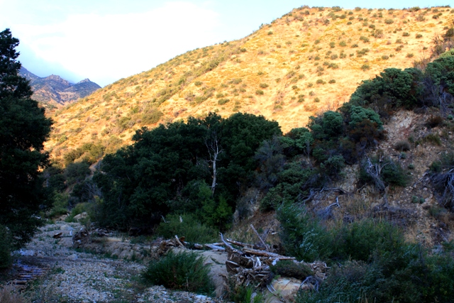
A fork in the creek bed.

As I strolled past a fork in the creek bed, taking the west fork leading through a prominent sandstone ridge, I came into a small potrero. It was studded with a wide-spaced, coarse type of bunch grass, and bordered on the north edge by a stand of densely clustered oaks trees rooted against a sandstone bench. I recognized its potential immediately and stood analyzing the landscape, thinking what a terrific area for a campsite.

In the wet season, water seeped from the mountain running before the potrero in a shallow flow and into the actual creek forming the east edge of the relatively flat nook. I started to my left walking over to take a gander around one of the clumps of oak trees to see what I might see when, for some reason, I decided to walk to the right instead. As I stepped into an open patch of dirt my eyes locked onto a arrowhead. As soon as I saw it I knew it was a point. I could not believe it and stood there grinning.

The point as found. The last person that touched this was a Chumash Indian many years ago.

What are the odds of stumbling across a one inch bit of stone on the side of a mountain? To think of all the individual choices I made that day that added up to having stepped directly over the top of that arrowhead. Incredible.

A funny thing about the find is that it was actually laying in the middle of an old foot print from somebody that had passed a few weeks prior. I could clearly see a footprint, and the arrowhead was right in the middle, where the arch of the foot would be.

I continued up the dry creek bed to the foot of a waterfall and, finding nothing of interest, plopped down beneath the brush beside the wall of water stained sandstone. After snacking on some provisions I dozed in the shade for the next hour waiting for the sun to drop a mite and the temperature to cool.

The next (dry) waterfall, which I broke my way through the brush to reach, was much larger at about a fifteen foot drop or so. A gravel bottomed depression in the otherwise circular dirt flat beneath the fall showed just how far the water shot off the ledge in a rainstorm, which was a considerable distance. Thinking that the collection of detritus where the water hits the ground was a great place to search for treasure, whatever that may be, I squatted down and took a look. I did not find any more arrowheads, but I did spot a fossil within a few seconds. A near fully intact fossilized snail shell was just laying there, which is not surprising for the area. They are embedded in the rocks and washed out in the creeks all over the Pine Mountain, but whole specimens completely free from the surrounding stone are harder to find.

A tiny fossilized snail shell.

I poked around the surrounding area a bit more and then began making my way back down the mountain as the sun was falling low on the horizon. Following my own tracks down the sandy creek bed toward the trail, I came onto a set of, what I believe to be, bear tracks. Last I time I was in the area, about a mile away, I saw tracks that were about half a day old. This time the bear had crossed my trail sometime after I hiked in. Down the creek I went following the fresh tracks as they appeared intermittently in the sandy patches, but never saw anything. Until later on the drive home when I rounded the corner of the road on top of Dry Lakes Ridge and saw the spectacular sunset view of the fog rolling in shown in the photo.

Posted in Ventura | Tagged , , , , , , , , , | Leave a comment