Fire Poppy, Baron Ranch Corridor

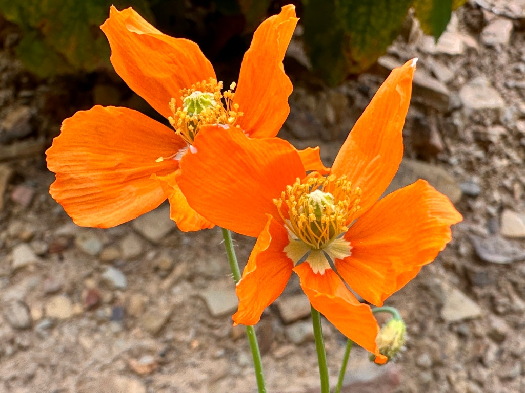
Fire poppies blooming along Baron Ranch Corridor.

An extraordinary flush of canyon sunflowers now covers many places likely to hold fire poppies.

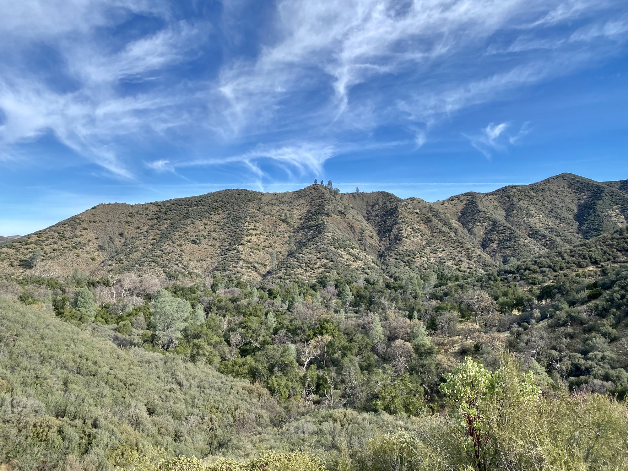
The curvaceous winding slopes under thickening oak canopy, cleaned by wildfire three years ago, now bulge with sunflower bushes standing four to six feet tall, shoulder to shoulder, as far as eyes can see through the late afternoon gloom of heavy sea fog.

In Refugio Canyon two canyons over, as made privy to by a commenter on the blog, more than 80 inches of rain have fallen this season.

The season prior rainfall county-wide measured in at over 200%-of-normal and in this water year we’re over 140%-of-normal so far.

The swiftly swelling forest is now closing fast, shrouding the mountain and erasing the Alisal Fire scar, disappearing the favored places to sprout of the fire poppies.

Who knows? They may not grow here for decades.

Last year I found two stands of the poppies far removed from each other, a smattering of plants each, perhaps a score, as many as I’ve ever seen at once anywhere, which is never many.

I don’t believe anybody else saw those particular plants or would know they even existed. I’m just telling it how it is. That’s all. 

They won’t let you see the plants.

How can you when they won’t allow a hillwalker to so much as set foot off their narrow little blinkered path?

In their purported “dedication to environmental stewardship and public access,” County of Santa Barbara officials and employees will not allow the few interested folks to see the most beautiful of “Gaviota’s ecological treasures.”

In the name of access and stewardship you can’t go and so you won’t know.

Although one of the growsites this year remains relatively open with some patches of bare soil or gravelly substrate still showing, not one plant could be found on this day by our indefatigable wanderer of lands of lesser interest.

This season a six hour walkabout turned up only two individual plants beside each other, as seen here, “immediately adjacent to the trail.”

Next year I expect none will be found.

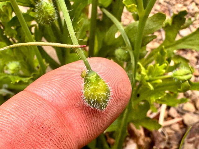
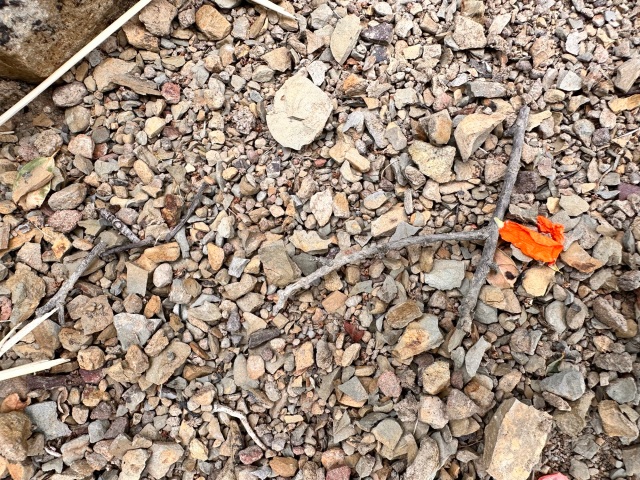
The tender plants grew from this rocky ground.

Related Posts:

The Twelve-Inch Experience, Baron Ranch Corridor

Big Bummer at Baron Ranch; Trashing the Place to Save It

Wind Poppy, Dick Smith Wilderness

Posted in Santa Barbara | Tagged , , , , , , , , , , | 2 Comments

Parks Management Co’s Selective Fee Enforcement

A valley of mixed woods,
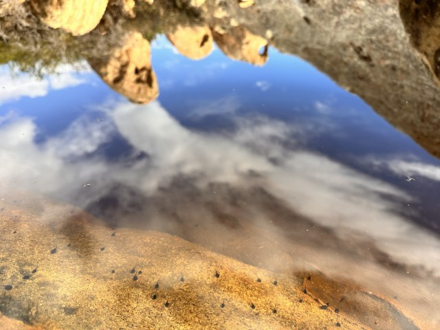
 Condor National Forest, Santa Barbara County.

RULE 4: “Make the enemy live up to its own book of rules.”  If the rule is that every letter gets a reply, send 30,000 letters.  You can kill them with this because no one can possibly obey all of their own rules.  (The besieged entity’s very credibility and reputation is at stake, because if activists catch it lying or not living up to its commitments, they can continue to chip away at the damage.)

–Saul Alinsky, Rules For Radicals (1971)

Does the concession to manage campgrounds granted to Parks Management Company by the US Forest Service stipulate that enforcement of campsite fee payment is subject to the discretion of the company?

It appears the company is not living up to its contractual commitment.

Is the company at liberty to pick and choose who pays and who does not?

Is selective enforcement legal?

Is this official Parks Management policy?

Is the US Forest Service officially aware of Parks Management’s selective enforcement?

We noticed long ago Parks Management had not bothered servicing campgrounds back of Figueroa Mountain during midweek. And Dan McCaslin in Noozhawk noted this a year ago.

We like a little free camping to be enjoyed by savvy locals and the fortunate few lucky others who show up at the right time. We also enjoy stopping in to BBQ at the campsites during hours we know Parks Management will not be there.

But shouldn’t we look at it from all angles?

Would you be frustrated if you happened to speak to a neighboring camper and find they didn’t have to pay, while you doled out nearly fifty bucks?

There are no exceptions to the fee stated on the bulletin board at campground entrances. It doesn’t say midweek is free or payment is only required if reserved online.

If reserved online in advance the base cost midweek starts at $38. Depending on how you decide to pay, you might just camp for free on the very same night other people are paying $48 for a two vehicle one night stay.

If the US Forest Service rule is that there are fees at these campgrounds, and if Parks Management signed onto the service contract as managers, then isn’t the company obligated to follow the rules?

Is not Parks Management responsible for enforcing fee payment just as much as the camping public is expected to be responsible for paying the fees?

If Parks Management is allowed to decide when or if following the rules is necessary, then are recreationists also allowed to decide for themselves at will when and wherever following rules is necessary in the forest?

Related Post:

Parks Management Company’s Red Rock Racket

Parks Management Company’s Red Rock Racket Continues

Parks Management Company’s Red Rock Racket and the Secret Green Ticket

Posted in Santa Barbara | Tagged , , , , , , , , , , | 2 Comments

Otter Point, Gaviota Coast

A cellphone snapshot from shore.

I combed the beach for over an hour before sitting to rest in the hook of the arroyo mouth.

The narrow, deep drainage chute cuts the shalestone sheets underlying the grassy plain of the coastal terrace and emerges onto the beach in the lee of a big point. Here surfer’s sit.

Some thirty years ago I kindled a fire here at this spot from salted driftwood, always burning with an inordinate reek, and dried my girlfriend’s shoe. She had slipped a foot into the water on accident during our beach walk.

Decades later she mentioned it in conversation as an early measure of a person she was still at that time getting to know. We were teenagers.

At that time no otters could possibly have been seen at this beach; they weren’t legally allowed to exist here, in their historic native range.

On a recent afternoon I sat here on a sunbleached log for a rest. I looked up to the scene before me for the first time, having been consumed with beachcombing all moments prior, chin to chest, eyes hard on the positive rake.

And there floated the sea otter before me. To see an otter in Gaviota waters today is to witness positive change in one’s lifetime.

By the 1930s, it’s said that fewer than 50 otters remained in existence in California waters, only around Big Sur, a remnant population that had survived over 100 years of hard pursuit by fur trappers.

From this small band the otters rebounded to their present population of about 3,000, having been listed under the Endangered Species Act in 1977.

But then from 1987, until the moratorium on removal was granted in 1993, under the No Otter Zone law, otters found in south county waters in Santa Barbara were forcibly relocated north of Point Conception. The anti-otter policy was not officially terminated until 2013.

Return of the otters to the Gaviota Coast has been a long time coming.

I sat watching the otter dive and eat whatever it was collecting from the seafloor.

Sometimes the otter would remain underwater for longer than usual, as if troubled by something particularly hard to get a hold of.

Then finally it’d rocket through the surface of the water with buoyant force enough to lift half its body into the air.

I thought of one of those lobsters you get a hand on once in awhile when freediving coastal shallows, but the bug is wedged deep in a cavity in the reefstone. You hold out as long as possible, trying with gentle force to pull the lobster out of its hole, until, desperate for air, you plunge upward breaking through the surface water in a violent, gasping rush.

Whenever the otter surfaced with its quarry the seagull would swim in close hoping to score some of the pickings.

On and on the game went, the otter and the gull, at otter’s point, along the Gaviota Coast.

Related Posts:

Gaviota Coast Gallivants: The Wildest Wilderness

Gaviota Coast Gallivants: Chumash Arrowhead

Gaviota Coast Gallivants: Then Came the Fox

Bald Eagle, Gaviota Coast

Posted in Santa Barbara | Tagged , , , , , , , , , , | 3 Comments

Ridgetop Tank, Santa Ynez Mountains

The ephemeral pool forms on the bedrock
high on a sandstone ridge
hundreds of feet above the creek,
otherwise filling the canyon with the sound of its rushing water,
but for the displaced croak of frogs
hole up in a lone pond in the sky,
and the polliwogs waiting,
water skeeters skating,
encircled by lichened rocks and chaparral,
glare of sun,
scent of sea.

tadpoles

The hitchhiker.

Related Post:

Lone Wandering

Posted in Santa Barbara | Tagged , , , , , , , , , , | 2 Comments

California Name Origins: Joseph Wood Krutch, The Forgotten Peninsula (1961)

Detail of Nicholas de Fer’s map from 1705 showing Santa Barbara Channel.

An excerpt from The Forgotten Peninsula: A Naturalist in Baja California (1961) by Joseph Wood Krutch detailing the suspected origins of the name California:

Most of the place names in Baja or elsewhere in Mexico are self-explanatory. Either they are derived from native words like Oaxaca or Tehuacan; they testify to recent revolutionary enthusiasm like “Libertad”; or they honor the saints and mysteries of the Catholic religion.

In Baja itself some of the favorite saints were honored so often that there are, for example, at least three Santo Domingos and three San Antonios, besides two All Saints (Todos Santos) and such other evidences of overwhelming religiosity as Immaculate Conception (La Purisima Conception), Guardian Angel Island (Angel de la Guarda) and Holy Ghost Island (Espiritu Santo).

The only really shocking exception is “Aunt Jane” (Tijuana). But that border town was not founded until 1830 and it acquired during the reign of Prohibition in the United States a reputation for wickedness which would have made any less secular name highly inappropriate.

The name “California” is quite a different matter. It fits no pattern and offers no evident explanation. 

When in 1535 Cortez took formal possession of what he thought was an island he displayed conspicuous lack of originality by calling it Santa Cruz — that being the name of the festival day on which the authority of the Spanish king was formally proclaimed.

Who, then, did literally “put California on the map” and where did he get the singularly euphonious name destined to become familiar to millions of an alien race?

Though its first-known use is in the journal of Juan Paez who wrote under the date July 2, 1542, “We came in sight of California” and though it appears again twelve years later in a published history of Mexico by one Gomara, its first known appearance “on the map” is a chart of 1562 where the name is applied to the tip of the peninsula.

Only by 1600 had it come to refer commonly to the whole of what we now call Baja California.

Three-quarters of a century later the two Jesuit missionaries, Father Juan Baegert and Father Francisco Clavijero, both of whom wrote accounts of Baja after they had been expelled with the other members of their Order from all of Spain, new or old, were speculating over the meaning of the universally accepted name.

Both were familiar with the guess, still current in our own time, that it was derived from “calida fornax” or “furnace,” but they were skeptical.

An even less probable origin suggested was the name of Ceasar’s wife, Calpurnia.

But the hot furnace theory was usually excepted, sometimes with the suggestion that it referred, not to the heat of deserts, but to the enclosed sweat baths which some of the aborigines were accustomed to build.

Barry Lawrence Ruderman Antique Maps — RareMaps.com

Nicholas De Fer’s “Cette Carte De Californie et Du Nouveau Mexique” (1705) showing California as an island.

Continuing without interruption, The Forgotten Peninsula: A Naturalist in Baja California (1961), by Joseph Wood Krutch:

There the matter rested until the American writer Edward Everett (“Man Without A County”) Hale chanced to read a chivalric romance “Amadis de Gaula” which Cervantes calls the “best of all the books of this kind that have ever been written” and which he spares from the flames to which all Don Quixote’s other books of chivalry are to be consigned.

The date, original authorship and ultimate source of this romance is one of the great problems of literary history, but in Cervante’s time it was enormously popular and the fourth book of the romance (apparently an addition) deals with the adventures of a son of Amadis who collects an army drawn from various Christian nations and goes to defend Constantinople against an attack by the king of Persia.

Among the allies of the pagans is a queen of the Amazons who rules an island “at the right hand of the Indies, very close to that part of the terrestrial paradise and inhabited by women without a single man among them.”

These warlike ladies are accompanied on their expedition by an air force composed of five hundred griffins (which are fortunately an important part of the avifauna of their island).

When first released near Jerusalem the griffins wreak havoc because they attack the Turks on the assumption that all men are enemies of the queen. But when this misconception is rectified they prove very effective.

In the end, however, the Christian forces are triumphant, the Amazon queen is converted to Christianity, and is given in marriage to a Christian hero. 

What has all this got to due with our subject?

Just this: Edward Everett Hale was startled to notice (and to notice that no one seemed to have noticed before him)  that name of the island ruled over by the Amazons was “California,” and the name of the queen herself, Califia.

According to the author of the tale the first of these names was derived from the Greek kalli “beautiful,” and ornis “bird” — because “in this island are many griffins.”

Hale did no more than call attention to his discovery and it probably seemed to him as, at first sight it must, somewhat farfetched.

The assiduous research of scholars (admirably summarized by Ruth Putnam in one of the University of California Publications in History) seems to confirm it so strongly that it is now generally accepted by historians, though my experience is that the man in the street will still say “hot furnace” if asked for an explanation.

The romance was so extremely well known at the time when Baja was discovered that any Spaniard even barely literate would have heard of it and very likely thought of Califia’s island in connection with any described as “near to the Indies.”

Moreover, Amazons had a special fascination for the early explorers (witness the name of the South American river) and now that these warlike ladies were known not to be found in Africa where they had formerly been supposed to live, the imagination eagerly relocated then in several other still sufficiently unknown lands.

Related Post:

The Origin of the Name California and the Island Myth

Posted in Santa Barbara | Tagged , , , , , , | 2 Comments